Xocourt
| Xocourt | ||
|---|---|---|
|
| |
| Staat | Frankreich | |
| Region | Grand Est | |
| Département (Nr.) | Moselle (57) | |
| Arrondissement | Sarrebourg-Château-Salins | |
| Kanton | Le Saulnois | |
| Gemeindeverband | Saulnois | |
| Koordinaten | 48° 54′ N, 6° 23′ O | |
| Höhe | 224–400 m | |
| Fläche | 4,95 km² | |
| Einwohner | 98 (1. Januar 2019) | |
| Bevölkerungsdichte | 20 Einw./km² | |
| Postleitzahl | 57590 | |
| INSEE-Code | 57755 | |
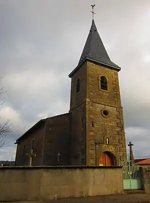 Kirche Saint-Martin | ||

Xocourt ist eine französische Gemeinde mit 98 Einwohnern (Stand 1. Januar 2019) im Département Moselle in der Region Grand Est (bis 2015 Lothringen). Sie gehört zum Arrondissement Sarrebourg-Château-Salins.
Geografie
Xocourt liegt südlich von Metz auf einer Höhe zwischen 224 und 400 m über dem Meeresspiegel, die mittlere Höhe beträgt 300 m. Das Gemeindegebiet umfasst 4,88 km².
Geschichte
Das kleine Dorf gehört seit 1661 zu Frankreich und trug 1915–18 den verdeutschten Namen Schollhofen bzw. 1940–44 Schellhofen.
Bevölkerungsentwicklung
| Jahr | 1962 | 1968 | 1975 | 1982 | 1990 | 1999 | 2007 | 2015 |
| Einwohner | 63 | 62 | 53 | 46 | 40 | 49 | 74 | 89 |
Siehe auch
Weblinks
Commons: Xocourt – Sammlung von Bildern, Videos und Audiodateien
This article is issued from Wikipedia. The text is licensed under Creative Commons - Attribution - Sharealike. The authors of the article are listed here. Additional terms may apply for the media files, click on images to show image meta data.