Léning
| Léning | ||
|---|---|---|
|
| |
| Staat | Frankreich | |
| Region | Grand Est | |
| Département (Nr.) | Moselle (57) | |
| Arrondissement | Sarrebourg-Château-Salins | |
| Kanton | Le Saulnois | |
| Gemeindeverband | Saulnois | |
| Koordinaten | 48° 57′ N, 6° 48′ O | |
| Höhe | 216–300 m | |
| Fläche | 6,52 km² | |
| Einwohner | 340 (1. Januar 2019) | |
| Bevölkerungsdichte | 52 Einw./km² | |
| Postleitzahl | 57670 | |
| INSEE-Code | 57394 | |

Léning (deutsch Leiningen) ist eine französische Gemeinde mit 340 Einwohnern (Stand 1. Januar 2019) im Département Moselle in der Region Grand Est (bis 2015 Lothringen). Sie gehört zum Arrondissement Sarrebourg-Château-Salins.
Geografie
Léning liegt an der Albe, vier Kilometer nordwestlich von Albestroff auf einer Höhe zwischen 216 und 300 m über dem Meeresspiegel. Das Gemeindegebiet umfasst 6,49 km².
Bevölkerungsentwicklung
| Jahr | 1962 | 1968 | 1975 | 1982 | 1990 | 1999 | 2007 |
| Einwohner | 195 | 196 | 183 | 180 | 205 | 210 | 276 |
Kultur und Sehenswürdigkeiten
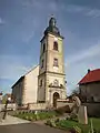 Kirche Saint-Barthélemy in Léning
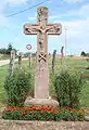 Flurkreuz in Léning
Weblinks
Commons: Léning – Sammlung von Bildern, Videos und Audiodateien
This article is issued from Wikipedia. The text is licensed under Creative Commons - Attribution - Sharealike. The authors of the article are listed here. Additional terms may apply for the media files, click on images to show image meta data.