Obreck
| Obreck | ||
|---|---|---|
|
| |
| Staat | Frankreich | |
| Region | Grand Est | |
| Département (Nr.) | Moselle (57) | |
| Arrondissement | Sarrebourg-Château-Salins | |
| Kanton | Le Saulnois | |
| Gemeindeverband | Saulnois | |
| Koordinaten | 48° 51′ N, 6° 36′ O | |
| Höhe | 208–306 m | |
| Fläche | 3,27 km² | |
| Einwohner | 33 (1. Januar 2019) | |
| Bevölkerungsdichte | 10 Einw./km² | |
| Postleitzahl | 57170 | |
| INSEE-Code | 57520 | |
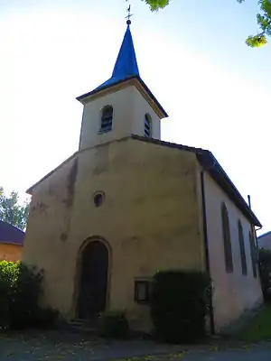 Kirche Saint-Clément | ||

Obreck ist eine französische Gemeinde mit 33 Einwohnern (Stand 1. Januar 2019) im Département Moselle in der Region Grand Est (bis 2015 Lothringen). Sie gehört zum Arrondissement Sarrebourg-Château-Salins.
Geografie
Obreck liegt an der Kleinen Seille, 7,5 Kilometer nordöstlich von Château-Salins auf einer Höhe zwischen 208 und 306 m über dem Meeresspiegel. Das Gemeindegebiet umfasst 3,24 km². Die Gemeinde liegt im Regionalen Naturpark Lothringen.
Bevölkerungsentwicklung
| Jahr | 1962 | 1968 | 1975 | 1982 | 1990 | 1999 | 2007 | 2014 |
|---|---|---|---|---|---|---|---|---|
| Einwohner | 90 | 62 | 55 | 39 | 46 | 40 | 53 | 42 |
Weblinks
Commons: Obreck – Sammlung von Bildern
This article is issued from Wikipedia. The text is licensed under Creative Commons - Attribution - Sharealike. The authors of the article are listed here. Additional terms may apply for the media files, click on images to show image meta data.