Oriocourt
| Oriocourt | ||
|---|---|---|
|
| |
| Staat | Frankreich | |
| Region | Grand Est | |
| Département (Nr.) | Moselle (57) | |
| Arrondissement | Sarrebourg-Château-Salins | |
| Kanton | Le Saulnois | |
| Gemeindeverband | Saulnois | |
| Koordinaten | 48° 52′ N, 6° 25′ O | |
| Höhe | 228–296 m | |
| Fläche | 4,50 km² | |
| Einwohner | 55 (1. Januar 2019) | |
| Bevölkerungsdichte | 12 Einw./km² | |
| Postleitzahl | 57590 | |
| INSEE-Code | 57525 | |
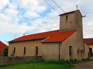 Kirche Saint-Jean-Baptiste | ||

Oriocourt ist eine französische Gemeinde mit 55 Einwohnern (Stand 1. Januar 2019) im Département Moselle in der Region Grand Est (bis 2015 Lothringen). Sie gehört zum Arrondissement Sarrebourg-Château-Salins.
Geografie
Oriocourt liegt südöstlich von Metz im Saulnois auf einer Höhe zwischen 228 und 296 m über dem Meeresspiegel. Das Gemeindegebiet umfasst 4,44 km².
Geschichte
Das Dorf gehört seit 1661 zu Frankreich und trug 1915–18 bzw. 1940–44 den verdeutschten Namen Orhofen. Von 1860 bis 2017 bestand hier das Benediktinerinnenkloster Oriocourt.
Bevölkerungsentwicklung
| Jahr | 1962 | 1968 | 1975 | 1982 | 1990 | 1999 | 2007 | 2017 |
| Einwohner | 89 | 95 | 94 | 80 | 66 | 58 | 51 | 57 |
Weblinks
Commons: Oriocourt – Sammlung von Bildern, Videos und Audiodateien
This article is issued from Wikipedia. The text is licensed under Creative Commons - Attribution - Sharealike. The authors of the article are listed here. Additional terms may apply for the media files, click on images to show image meta data.