Bannay (Moselle)
| Bannay | ||
|---|---|---|

|
| |
| Staat | Frankreich | |
| Region | Grand Est | |
| Département (Nr.) | Moselle (57) | |
| Arrondissement | Forbach-Boulay-Moselle | |
| Kanton | Boulay-Moselle | |
| Gemeindeverband | Houve-Pays Boulageois | |
| Koordinaten | 49° 8′ N, 6° 28′ O | |
| Höhe | 212–327 m | |
| Fläche | 4,12 km² | |
| Einwohner | 73 (1. Januar 2019) | |
| Bevölkerungsdichte | 18 Einw./km² | |
| Postleitzahl | 57220 | |
| INSEE-Code | 57048 | |
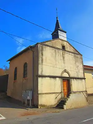
 Mariä Geburt-Kirche | ||
Bannay (deutsch Bizingen, lothringisch Bénaïe) ist eine französische Gemeinde mit 73 Einwohnern (Stand 1. Januar 2019) im Département Moselle in der Region Grand Est (bis 2015 Lothringen).
Geografie
Die Gemeinde Bannay liegt an der Deutschen Nied, etwa 20 Kilometer östlich von Metz. Zur Gemeinde gehört auch der südwestlich gelegene Weiler Itzing.
Geschichte
Das Dorf gehört seit 1769 zu Frankreich, vorher war es Teil der österreichischen Exklave Rollingen. Von 1871 bis 1918 gehörte Bannay zum Deutschen Reich.
Bevölkerungsentwicklung
| Jahr | 1962 | 1968 | 1975 | 1982 | 1990 | 1999 | 2007 | 2018 |
| Einwohner | 59 | 69 | 61 | 72 | 78 | 71 | 78 | 74 |
Weblinks
Commons: Bannay – Sammlung von Bildern, Videos und Audiodateien
This article is issued from Wikipedia. The text is licensed under Creative Commons - Attribution - Sharealike. The authors of the article are listed here. Additional terms may apply for the media files, click on images to show image meta data.
