Ham-sous-Varsberg
| Ham-sous-Varsberg | ||
|---|---|---|
|
| |
| Staat | Frankreich | |
| Region | Grand Est | |
| Département (Nr.) | Moselle (57) | |
| Arrondissement | Forbach-Boulay-Moselle | |
| Kanton | Boulay-Moselle | |
| Gemeindeverband | Warndt | |
| Koordinaten | 49° 11′ N, 6° 39′ O | |
| Höhe | 213–332 m | |
| Fläche | 6,53 km² | |
| Einwohner | 2.848 (1. Januar 2019) | |
| Bevölkerungsdichte | 436 Einw./km² | |
| Postleitzahl | 57880 | |
| INSEE-Code | 57288 | |
| Website | https://www.hamsousvarsberg.fr/ | |

Ham-sous-Varsberg (deutsch Ham unter Varsberg bzw. 1941–1944 Hamm unter Warsberg) ist eine französische Gemeinde mit 2848 Einwohnern (Stand 1. Januar 2019) im Département Moselle in der Region Grand Est (bis 2016 Lothringen). Ham-sous-Varsberg gehört zum Arrondissement Forbach-Boulay-Moselle.
Geografie
Ham-sous-Varsberg liegt am Westrand des Warndt, unweit der Grenze zum Saarland. Nachbarorte sind Creutzwald, Diesen, Porcelette, Varsberg, Boucheporn und Guerting.
Bevölkerungsentwicklung
| Jahr | 1962 | 1968 | 1975 | 1982 | 1990 | 1999 | 2007 | 2015 |
| Einwohner | 2.115 | 2.303 | 2.549 | 2.762 | 2.801 | 2.707 | 2.763 | 2.816 |
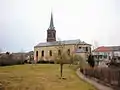 Kirche Saint-Lambert von 1820
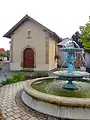 Kapelle Ham-sous-Varsberg
This article is issued from Wikipedia. The text is licensed under Creative Commons - Attribution - Sharealike. The authors of the article are listed here. Additional terms may apply for the media files, click on images to show image meta data.