Roupeldange
| Roupeldange | ||
|---|---|---|

|
| |
| Staat | Frankreich | |
| Region | Grand Est | |
| Département (Nr.) | Moselle (57) | |
| Arrondissement | Forbach-Boulay-Moselle | |
| Kanton | Boulay-Moselle | |
| Gemeindeverband | Houve-Pays Boulageois | |
| Koordinaten | 49° 12′ N, 6° 28′ O | |
| Höhe | 198–242 m | |
| Fläche | 2,64 km² | |
| Einwohner | 362 (1. Januar 2019) | |
| Bevölkerungsdichte | 137 Einw./km² | |
| Postleitzahl | 57220 | |
| INSEE-Code | 57599 | |
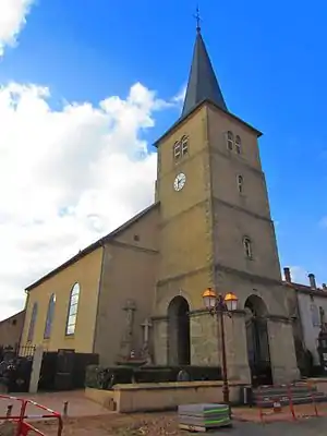
 Kirche Sainte-Barbe | ||
Roupeldange (deutsch Ruplingen) ist eine französische Gemeinde mit 362 Einwohnern (Stand 1. Januar 2019) im Département Moselle in der Region Grand Est (bis 2015 Lothringen).
Lage
Die Gemeinde liegt an der Nied, drei Kilometer nordwestlich von Boulay-Moselle.
Geschichte
Roupelange wurde erstmals als Rubildinga im 12. Jahrhundert erwähnt. Weitere Namen waren Ruppeldeng (1271), Roupeldanges (1300), Rupplingen aliàs Ruppeldanges (1594), Ruplingen (1606), Raupeldingen (1693), Rupeldange (1779)[1].
Bevölkerungsentwicklung
| Jahr | 1793 | 1896 | 1954 | 1982 | 1990 | 2009 | 2018 |
| Einwohner | 241 | 266 | 201 | 334 | 387 | 374 | 368 |
Sehenswürdigkeiten
- Kirche Sainte-Barbe von 1765
Weblinks
Commons: Roupeldange – Sammlung von Bildern, Videos und Audiodateien
Einzelnachweise
- Bouteiller - Dictionnaire topographique de l'ancien département de la Moselle.
This article is issued from Wikipedia. The text is licensed under Creative Commons - Attribution - Sharealike. The authors of the article are listed here. Additional terms may apply for the media files, click on images to show image meta data.
