Fouligny
| Fouligny | ||
|---|---|---|
|
| |
| Staat | Frankreich | |
| Region | Grand Est | |
| Département (Nr.) | Moselle (57) | |
| Arrondissement | Forbach-Boulay-Moselle | |
| Kanton | Faulquemont | |
| Gemeindeverband | District Urbain de Faulquemont | |
| Koordinaten | 49° 6′ N, 6° 30′ O | |
| Höhe | 219–315 m | |
| Fläche | 6,02 km² | |
| Einwohner | 195 (1. Januar 2019) | |
| Bevölkerungsdichte | 32 Einw./km² | |
| Postleitzahl | 57220 | |
| INSEE-Code | 57230 | |
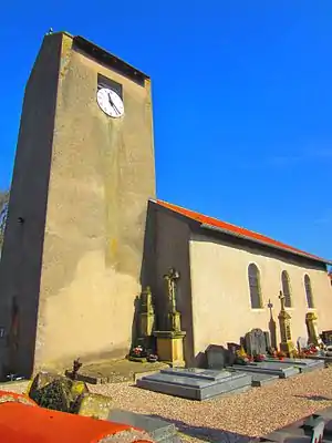 Kirche Saint-Rémi | ||

Fouligny (deutsch Füllingen, fränkisch Fillingen) ist eine französische Gemeinde mit 195 Einwohnern (Stand 1. Januar 2019) im Département Moselle in der Region Grand Est (bis 2015 Lothringen).
Geografie
Fouligny liegt an der Nationalstraße N3 zwischen Saint-Avold und Metz am Ufer der Deutschen Nied, etwa 40 Kilometer von Saarbrücken entfernt.
Geschichte
Historische Namen des Ortes: Fullinga (1181), Fuligny (1245), Vollingia (1299), Fullingam (1302), Fullenges (1420), Fullenga – Fullingen (1544), Filling (1594), Foligny (1662), Ullinge – Ullenge (1681), Filling – Folligni (1688), Foligny (spätes 17. Jh.), Fouligny, Füllingen (1871), Fouligny (1918), Füllingen (2. August 1940), Fouligny (1944).[1]
Bevölkerungsentwicklung
| Jahr | 1962 | 1968 | 1975 | 1982 | 1990 | 1999 | 2007 | 2018 |
| Einwohner | 137 | 151 | 136 | 177 | 175 | 191 | 201 | 195 |
Sehenswertes
- Die Mühle von Fouligny ist die einzige Wassermühle im Arrondissement Boulay-Moselle, die noch in Betrieb ist.
Belege
- Ernest de Bouteiller: „Dictionnaire topographique de l'ancien département de la Moselle“, 1868.
Weblinks
Commons: Fouligny – Sammlung von Bildern, Videos und Audiodateien
This article is issued from Wikipedia. The text is licensed under Creative Commons - Attribution - Sharealike. The authors of the article are listed here. Additional terms may apply for the media files, click on images to show image meta data.