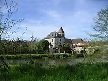
Corgnac-sur-l’Isle
Corgnac-sur-l’Isle (okzitanisch Cornhac d’Eila) ist eine französische Gemeinde mit 838 Einwohnern (Stand 1. Januar 2019) im Département Dordogne in der Region Nouvelle-Aquitaine. Bis 1906 lautete der Ortsname Corgnac.
| Corgnac-sur-l’Isle | ||
|---|---|---|
| ||
| Staat | Frankreich | |
| Region | Nouvelle-Aquitaine | |
| Département (Nr.) | Dordogne (24) | |
| Arrondissement | Nontron | |
| Kanton | Thiviers | |
| Gemeindeverband | Périgord-Limousin | |
| Koordinaten | 45° 23′ N, 0° 57′ O | |
| Höhe | 128–255 m | |
| Fläche | 21,60 km² | |
| Einwohner | 838 (1. Januar 2019) | |
| Bevölkerungsdichte | 39 Einw./km² | |
| Postleitzahl | 24800 | |
| INSEE-Code | 24134 | |
Corgnac-sur-l’Isle liegt am Fluss Isle, der südlich von Limoges im Zentralmassiv entspringt und bei Libourne in die Dordogne mündet. Die Gemeinde liegt außerdem an der Straße D 76, die von Thiviers nach Excideuil führt.
Bevölkerungsentwicklung
| 1962 | 1968 | 1975 | 1982 | 1990 | 1999 | 2011 | 2018 |
|---|---|---|---|---|---|---|---|
| 1044 | 1021 | 957 | 866 | 888 | 840 | 797 | 833 |
Sehenswürdigkeiten
- romanische Kirche Saint-Front
- alte Brücke über die Isle
- Schloss von Laxion (15. bis 16. Jahrhundert)

Blick auf die Dorfkirche in Corgnac-sur-l’Isle
This article is issued from Wikipedia. The text is licensed under Creative Commons - Attribution - Sharealike. The authors of the article are listed here. Additional terms may apply for the media files, click on images to show image meta data.
