Coin-lès-Cuvry
| Coin-lès-Cuvry | ||
|---|---|---|
|
| |
| Staat | Frankreich | |
| Region | Grand Est | |
| Département (Nr.) | Moselle (57) | |
| Arrondissement | Metz | |
| Kanton | Les Coteaux de Moselle | |
| Gemeindeverband | Metz Métropole | |
| Koordinaten | 49° 2′ N, 6° 9′ O | |
| Höhe | 171–235 m | |
| Fläche | 6,66 km² | |
| Einwohner | 796 (1. Januar 2019) | |
| Bevölkerungsdichte | 120 Einw./km² | |
| Postleitzahl | 57420 | |
| INSEE-Code | 57146 | |

Coin-lès-Cuvry ist eine französische Gemeinde mit 796 Einwohnern (Stand 1. Januar 2019) im Département Moselle in der Region Grand Est (bis 2015 Lothringen). Sie gehört zum Arrondissement Metz.
Geografie
Die Gemeinde Coin-lès-Cuvry (Coin bei Cuvry) liegt im Tal der Seille, etwa zehn Kilometer südlich von Metz auf einer Höhe zwischen 171 und 235 m über dem Meeresspiegel. Das Gemeindegebiet umfasst 6,65 km².
Geschichte
Das Dorf wurde 1367 erstmals als Coing erwähnt.
In den Jahren von 1915 bis 1918 und 1940 bis 1944 trug Coin-lès-Cuvry den verdeutschten Namen Kuberneck.
Bevölkerungsentwicklung
| Jahr | 1962 | 1968 | 1975 | 1982 | 1990 | 1999 | 2007 |
| Einwohner | 220 | 242 | 254 | 522 | 571 | 667 | 707 |
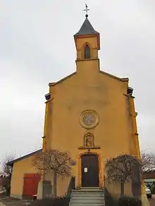
Kirche St. Bartholomäus
Weblinks
Commons: Coin-lès-Cuvry – Sammlung von Bildern, Videos und Audiodateien
This article is issued from Wikipedia. The text is licensed under Creative Commons - Attribution - Sharealike. The authors of the article are listed here. Additional terms may apply for the media files, click on images to show image meta data.