Saint-Jean-le-Vieux (Isère)
Saint-Jean-le-Vieux ist eine französische Gemeinde mit 300 Einwohnern (Stand: 1. Januar 2019) im Département Isère in der Region Auvergne-Rhône-Alpes (vor 2016 Rhône-Alpes). Saint-Jean-le-Vieux gehört zum Arrondissement Grenoble und zum Kanton Le Moyen Grésivaudan (bis 2015 Domène). Die Einwohner nennen sich Jactous.
| Saint-Jean-le-Vieux | ||
|---|---|---|
| ||
| Staat | Frankreich | |
| Region | Auvergne-Rhône-Alpes | |
| Département (Nr.) | Isère (38) | |
| Arrondissement | Grenoble | |
| Kanton | Le Moyen Grésivaudan | |
| Gemeindeverband | Le Grésivaudan | |
| Koordinaten | 45° 13′ N, 5° 53′ O | |
| Höhe | 313–1169 m | |
| Fläche | 4,68 km² | |
| Einwohner | 300 (1. Januar 2019) | |
| Bevölkerungsdichte | 64 Einw./km² | |
| Postleitzahl | 38420 | |
| INSEE-Code | 38404 | |
| Website | https://www.saintjeanlevieux.fr/ | |
_abc18.JPG.webp) Rathaus (Mairie) von Saint-Jean-le-Vieux | ||

Geographie
Saint-Jean-le-Vieux liegt etwa elf Kilometer ostnordöstlich von Grenoble in einem Tal des Grésivaudan. Umgeben wird Saint-Jean-le-Vieux von den Nachbargemeinden Le Versoud im Norden und Westen, La Combe-de-Lancey im Osten und Nordosten, Revel im Süden sowie Domène im Westen.
Bevölkerungsentwicklung
| Jahr | 1962 | 1968 | 1975 | 1982 | 1990 | 1999 | 2006 | 2013 |
|---|---|---|---|---|---|---|---|---|
| Einwohner | 138 | 104 | 99 | 149 | 173 | 203 | 210 | 262 |
| Quellen: Cassini und INSEE | ||||||||
Sehenswürdigkeiten
- Kirche Saint-Jean-Baptiste aus dem 11. Jahrhundert, seit 2004 Monument historique
- Turm Le Couvat aus dem 13. Jahrhundert
Weblinks
Commons: Saint-Jean-le-Vieux – Sammlung von Bildern, Videos und Audiodateien
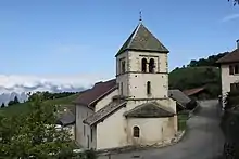
Kirche Saint-Jean-Baptiste
This article is issued from Wikipedia. The text is licensed under Creative Commons - Attribution - Sharealike. The authors of the article are listed here. Additional terms may apply for the media files, click on images to show image meta data.