Pont-en-Royans
Pont-en-Royans ist eine französische Gemeinde im Département Isère in der Region Auvergne-Rhône-Alpes. Sie liegt auf etwa 210 Metern Höhe und hat 785 Einwohner (Stand 1. Januar 2019).
| Pont-en-Royans | ||
|---|---|---|
.svg.png.webp)
|
| |
| Staat | Frankreich | |
| Region | Auvergne-Rhône-Alpes | |
| Département (Nr.) | Isère (38) | |
| Arrondissement | Grenoble | |
| Kanton | Le Sud Grésivaudan | |
| Gemeindeverband | Saint-Marcellin Vercors Isère Communauté | |
| Koordinaten | 45° 4′ N, 5° 21′ O | |
| Höhe | 183–788 m | |
| Fläche | 2,89 km² | |
| Einwohner | 785 (1. Januar 2019) | |
| Bevölkerungsdichte | 272 Einw./km² | |
| Postleitzahl | 38680 | |
| INSEE-Code | 38319 | |
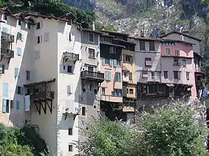 Die Häuser liegen malerisch in der Schlucht | ||

Geographie
Das Dorf liegt am Fluss Bourne, einem Nebenfluss der Isère. Das Gemeindegebiet gehört zum Regionalen Naturpark Vercors.
Bevölkerung
| Jahr | 1962 | 1968 | 1975 | 1982 | 1990 | 1999 |
|---|---|---|---|---|---|---|
| Einwohner | 1126 | 1132 | 1094 | 1051 | 879 | 917 |
| Quellen: Cassini und INSEE | ||||||
This article is issued from Wikipedia. The text is licensed under Creative Commons - Attribution - Sharealike. The authors of the article are listed here. Additional terms may apply for the media files, click on images to show image meta data.