Hurtières
Hurtières ist eine französische Gemeinde mit 195 Einwohnern (Stand: 1. Januar 2019) im Département Isère in der Region Auvergne-Rhône-Alpes; sie gehört zum Arrondissement Grenoble und zum Kanton Haut-Grésivaudan (bis 2015: Kanton Goncelin). Die Einwohner werden Hurtièrois genannt.
| Hurtières | ||
|---|---|---|
| ||
| Staat | Frankreich | |
| Region | Auvergne-Rhône-Alpes | |
| Département (Nr.) | Isère (38) | |
| Arrondissement | Grenoble | |
| Kanton | Haut-Grésivaudan | |
| Gemeindeverband | Le Grésivaudan | |
| Koordinaten | 45° 17′ N, 5° 58′ O | |
| Höhe | 429–1038 m | |
| Fläche | 3,42 km² | |
| Einwohner | 195 (1. Januar 2019) | |
| Bevölkerungsdichte | 57 Einw./km² | |
| Postleitzahl | 38570 | |
| INSEE-Code | 38192 | |

Geografie
Hurtières ist eine Gemeinde im Grésivaudan. Umgeben wird Hurtières von den Nachbargemeinden Theys im Norden und Osten, Les Adrets im Süden, Le Champ-près-Froges im Südwesten sowie La Pierre im Westen.
Bevölkerungsentwicklung
| Jahr | 1962 | 1968 | 1975 | 1982 | 1990 | 1999 | 2006 | 2017 |
| Einwohner | 105 | 85 | 58 | 53 | 95 | 121 | 166 | 168 |
| Quellen: Cassini und INSEE | ||||||||
Weblinks
Commons: Hurtières – Sammlung von Bildern, Videos und Audiodateien
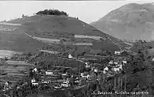
Hurtières auf einer alten Postkarte
This article is issued from Wikipedia. The text is licensed under Creative Commons - Attribution - Sharealike. The authors of the article are listed here. Additional terms may apply for the media files, click on images to show image meta data.