Susville
Susville ist eine französische Gemeinde mit 1.206 Einwohnern (Stand: 1. Januar 2019) im Département Isère in der Region Auvergne-Rhône-Alpes. Die Gemeinde liegt im Arrondissement Grenoble und gehört zum Kanton Matheysine-Trièves (bis 2015: Kanton La Mure).
| Susville | ||
|---|---|---|
| ||
| Staat | Frankreich | |
| Region | Auvergne-Rhône-Alpes | |
| Département (Nr.) | Isère (38) | |
| Arrondissement | Grenoble | |
| Kanton | Matheysine-Trièves | |
| Gemeindeverband | Matheysine | |
| Koordinaten | 44° 55′ N, 5° 47′ O | |
| Höhe | 874–1600 m | |
| Fläche | 10,05 km² | |
| Einwohner | 1.206 (1. Januar 2019) | |
| Bevölkerungsdichte | 120 Einw./km² | |
| Postleitzahl | 38350 | |
| INSEE-Code | 38499 | |
| Website | http://susvilleinfo.canalblog.com/ | |
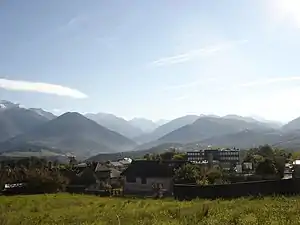 Blick auf Susville | ||

Geographie
Susville liegt etwa 35 Kilometer südsüdöstlich von Grenoble am Flüsschen Jonche. Umgeben wird Susville von den Nachbargemeinden Pierre-Châtel im Norden, La Mure im Osten und Südosten, Prunières im Süden sowie La Motte-d’Aveillans im Westen und Nordwesten.
Am Ostrand der Gemeinde führt die Route nationale 85 entlang.
Bevölkerungsentwicklung
| Jahr | 1962 | 1968 | 1975 | 1982 | 1990 | 1999 | 2006 | 2013 |
|---|---|---|---|---|---|---|---|---|
| Einwohner | 1863 | 1611 | 1299 | 1540 | 1430 | 1472 | 1443 | 1352 |
| Quellen: Cassini und INSEE | ||||||||
Sehenswürdigkeiten
- Kirche
- Zeche Villaret
This article is issued from Wikipedia. The text is licensed under Creative Commons - Attribution - Sharealike. The authors of the article are listed here. Additional terms may apply for the media files, click on images to show image meta data.