Montbonnot-Saint-Martin
| Montbonnot-Saint-Martin | ||
|---|---|---|
|
| |
| Staat | Frankreich | |
| Region | Auvergne-Rhône-Alpes | |
| Département (Nr.) | Isère (38) | |
| Arrondissement | Grenoble | |
| Kanton | Meylan | |
| Gemeindeverband | Le Grésivaudan | |
| Koordinaten | 45° 14′ N, 5° 48′ O | |
| Höhe | 215–356 m | |
| Fläche | 6,61 km² | |
| Einwohner | 5.477 (1. Januar 2019) | |
| Bevölkerungsdichte | 829 Einw./km² | |
| Postleitzahl | 38330 | |
| INSEE-Code | 38249 | |
| Website | www.montbonnot.fr | |
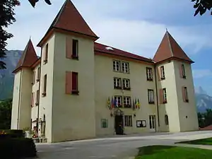 Rathaus von Montbonnot-Saint-Martin | ||

Montbonnot-Saint-Martin ist eine französische Gemeinde mit 5477 Einwohnern (Stand: 1. Januar 2019) im Département Isère in der Region Auvergne-Rhône-Alpes. Montbonnot-Saint-Martin gehört zum Arrondissement Grenoble und zum Kanton Meylan. Die Einwohner nennen sich Bonimontains.
Geographie
Montbonnot-Saint-Martin liegt am Nordufer der Isère. Umgeben wird Montbonnot-Saint-Martin von den Nachbargemeinden Saint-Ismier im Norden und Osten, Domène im Süden und Südosten, Meylan im Westen sowie Biviers im Nordwesten.
Durch die Gemeinde führt die Autoroute A41.
Bevölkerungsentwicklung
| Jahr | 1962 | 1968 | 1975 | 1982 | 1990 | 1999 | 2006 | 2011 | 2018 |
|---|---|---|---|---|---|---|---|---|---|
| Einwohner | 782 | 1016 | 1735 | 1859 | 2808 | 3827 | 4487 | 4681 | 5306 |
| Quellen: Cassini und INSEE | |||||||||
Sehenswürdigkeiten
- Schloss und Park Miribel (heutiges Rathaus)
- Inovallée, modernes Gewerbeparkgelände
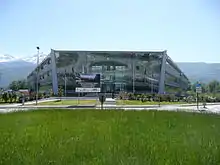
Inovallée
Persönlichkeiten
- Marie François Joseph de Miribel (1831–1893), General
This article is issued from Wikipedia. The text is licensed under Creative Commons - Attribution - Sharealike. The authors of the article are listed here. Additional terms may apply for the media files, click on images to show image meta data.