Saint-Marcellin Vercors Isère Communauté
Die Saint-Marcellin Vercors Isère Communauté ist ein französischer Gemeindeverband mit der Rechtsform einer Communauté de communes im Département Isère in der Region Auvergne-Rhône-Alpes. Sie wurde am 1. Januar 2017 gegründet und umfasst 47 Gemeinden. Der Sitz der Verwaltung befindet sich im Ort Saint-Marcellin.[2]
| Saint-Marcellin Vercors Isère Communauté | |
| Region(en) | Auvergne-Rhône-Alpes |
| Département(s) | Isère |
| Gründungsdatum | 1. Januar 2017 |
| Rechtsform | Communauté de communes |
| Verwaltungssitz | Saint-Marcellin |
| Gemeinden | 47 |
| Präsident | Frédéric de Azevedo |
| SIREN-Nummer | 200 070 431 |
| Fläche | 595,79 km² |
| Einwohner | 44.461 (2019)[1] |
| Bevölkerungsdichte | 75 Einw./km² |
| Website | http://www.saintmarcellin-vercors-isere.fr/ |
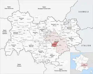 Lage des Gemeindeverbandes in der Region Auvergne-Rhône-Alpes | |
Historische Entwicklung
Der Gemeindeverband entstand mit Wirkung vom 1. Januar 2017 durch die Fusion der Vorgängerorganisationen Communauté de communes Chambaran Vinay Vercors, Communauté de communes de la Bourne à l’Isère und Communauté de communes du Pays de Saint-Marcellin.
Der ursprünglich unter dem Namen Communauté de communes du Sud Grésivaudan gegründete Verband wurde 2017 auf die aktuelle Bezeichnung umbenannt.
Mitgliedsgemeinden
| Gemeinde | Einwohner 1. Januar 2019 |
Fläche km² |
Dichte Einw./km² |
Code INSEE |
Postleitzahl |
|---|---|---|---|---|---|
| Auberives-en-Royans | 363 | 5,10 | 71 | 38018 | 38680 |
| Beaulieu | 635 | 8,78 | 72 | 38033 | 38470 |
| Beauvoir-en-Royans | 95 | 2,04 | 47 | 38036 | 38160 |
| Bessins | 107 | 4,66 | 23 | 38041 | 38160 |
| Chantesse | 360 | 5,82 | 62 | 38074 | 38470 |
| Chasselay | 402 | 9,46 | 42 | 38086 | 38470 |
| Châtelus | 91 | 12,56 | 7 | 38092 | 38680 |
| Chatte | 2.480 | 22,84 | 109 | 38095 | 38160 |
| Chevrières | 726 | 16,50 | 44 | 38099 | 38160 |
| Choranche | 120 | 10,59 | 11 | 38108 | 38680 |
| Cognin-les-Gorges | 630 | 12,65 | 50 | 38117 | 38470 |
| Cras | 432 | 5,49 | 79 | 38137 | 38210 |
| Izeron | 745 | 16,99 | 44 | 38195 | 38160 |
| L’Albenc | 1.279 | 10,08 | 127 | 38004 | 38470 |
| La Rivière | 740 | 18,35 | 40 | 38338 | 38210 |
| La Sône | 585 | 3,07 | 191 | 38495 | 38840 |
| Malleval-en-Vercors | 54 | 14,17 | 4 | 38216 | 38470 |
| Montagne | 269 | 8,78 | 31 | 38245 | 38160 |
| Montaud | 524 | 14,40 | 36 | 38248 | 38210 |
| Morette | 391 | 6,30 | 62 | 38263 | 38210 |
| Murinais | 399 | 8,18 | 49 | 38272 | 38160 |
| Notre-Dame-de-l’Osier | 498 | 8,56 | 58 | 38278 | 38470 |
| Poliénas | 1.212 | 13,71 | 88 | 38310 | 38210 |
| Pont-en-Royans | 785 | 2,89 | 272 | 38319 | 38680 |
| Presles | 92 | 25,51 | 4 | 38322 | 38680 |
| Quincieu | 102 | 4,77 | 21 | 38330 | 38470 |
| Rencurel | 324 | 34,57 | 9 | 38333 | 38680 |
| Rovon | 611 | 12,03 | 51 | 38345 | 38470 |
| Saint Antoine l’Abbaye | 1.162 | 35,96 | 32 | 38359 | 38160 |
| Saint-André-en-Royans | 310 | 10,48 | 30 | 38356 | 38680 |
| Saint-Appolinard | 414 | 10,58 | 39 | 38360 | 38160 |
| Saint-Bonnet-de-Chavagne | 653 | 15,19 | 43 | 38370 | 38840 |
| Saint-Gervais | 544 | 13,28 | 41 | 38390 | 38470 |
| Saint-Hilaire-du-Rosier | 1.869 | 16,34 | 114 | 38394 | 38840 |
| Saint-Just-de-Claix | 1.311 | 11,62 | 113 | 38409 | 38680 |
| Saint-Lattier | 1.399 | 18,11 | 77 | 38410 | 38840 |
| Saint-Marcellin | 7.766 | 7,80 | 996 | 38416 | 38160 |
| Saint-Pierre-de-Chérennes | 465 | 11,92 | 39 | 38443 | 38160 |
| Saint-Quentin-sur-Isère | 1.475 | 19,61 | 75 | 38450 | 38210 |
| Saint-Romans | 1.785 | 17,08 | 105 | 38453 | 38160 |
| Saint-Sauveur | 2.107 | 9,32 | 226 | 38454 | 38160 |
| Saint-Vérand | 1.713 | 17,67 | 97 | 38463 | 38160 |
| Serre-Nerpol | 308 | 13,09 | 24 | 38275 | 38470 |
| Têche | 574 | 5,05 | 114 | 38500 | 38470 |
| Varacieux | 843 | 18,55 | 45 | 38523 | 38470 |
| Vatilieu | 360 | 9,28 | 39 | 38526 | 38470 |
| Vinay | 4.352 | 16,01 | 272 | 38559 | 38470 |
| Saint-Marcellin Vercors Isère Communauté |
44.461 | 595,79 | 75 | – | – |
Quellen
- www.collectivites-locales.gouv.fr
- CC Saint-Marcellin Vercors Isère Communauté (SIREN: 200 070 431) in der Base nationale sur l’intercommunalité (BANATIC) des französischen Innenministeriums (französisch)
(Stand 1. Januar 2019)
Balcons du Dauphiné | Bièvre Est | Bièvre Isère | Cœur de Chartreuse* | Collines du Nord Dauphiné | Entre Bièvre et Rhône | Le Grésivaudan | Lyon Saint Exupéry en Dauphiné | Massif du Vercors | Matheysine | Oisans | Saint-Marcellin Vercors Isère Communauté | Trièves | Vals du Dauphiné
Communautés d’agglomération:
Pays Voironnais |
Porte de l’Isère |
Vienne Condrieu*
Métropoles:
Grenoble-Alpes-Métropole
Den mit * gekennzeichneten Gemeindeverbänden gehören auch Gemeinden an, die in anderen Départements liegen.