Villette (Meurthe-et-Moselle)
| Villette | ||
|---|---|---|
|
| |
| Staat | Frankreich | |
| Region | Grand Est | |
| Département (Nr.) | Meurthe-et-Moselle (54) | |
| Arrondissement | Briey | |
| Kanton | Mont-Saint-Martin | |
| Gemeindeverband | Terre Lorraine du Longuyonnais | |
| Koordinaten | 49° 29′ N, 5° 33′ O | |
| Höhe | 197–352 m | |
| Fläche | 4,66 km² | |
| Einwohner | 183 (1. Januar 2019) | |
| Bevölkerungsdichte | 39 Einw./km² | |
| Postleitzahl | 54260 | |
| INSEE-Code | 54582 | |

Villette ist eine französische Gemeinde mit 183 Einwohnern (Stand: 1. Januar 2019) im Département Meurthe-et-Moselle in der Region Grand Est (bis 2015 Lothringen). Sie gehört zum Arrondissement Briey und zum Kanton Mont-Saint-Martin (bis 2015: Kanton Longuyon). Die Einwohner werden Villettiens genannt.
Geografie
Villette liegt etwa 80 Kilometer nordwestlich von Metz am Chiers, der die Gemeinde im Westen begrenzt. Nachbargemeinden von Villette sind Charency-Vezin im Norden und Westen, Longuyon im Norden und Osten sowie Colmey im Süden.
Im Gemeindegebiet liegt der Flugplatz Longuyon-Villette.
Bevölkerungsentwicklung
| Jahr | 1962 | 1968 | 1975 | 1982 | 1990 | 1999 | 2006 | 2013 |
| Einwohner | 196 | 185 | 172 | 188 | 188 | 212 | 205 | 183 |
| Quelle: Cassini und INSEE | ||||||||
Sehenswürdigkeiten
- Kirche Saint-Symphorien
- Burg Villette
- französischer Soldatenfriedhof
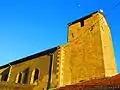 Kirche Saint-Symphorien
_en_2013.jpg.webp) Burg Villette
Burg Villette
This article is issued from Wikipedia. The text is licensed under Creative Commons - Attribution - Sharealike. The authors of the article are listed here. Additional terms may apply for the media files, click on images to show image meta data.