Errouville
| Errouville | ||
|---|---|---|
|
| |
| Staat | Frankreich | |
| Region | Grand Est | |
| Département (Nr.) | Meurthe-et-Moselle (54) | |
| Arrondissement | Briey | |
| Kanton | Villerupt | |
| Gemeindeverband | Pays de l’Audunois et du Bassin de Landres | |
| Koordinaten | 49° 25′ N, 5° 54′ O | |
| Höhe | 327–422 m | |
| Fläche | 5,26 km² | |
| Einwohner | 699 (1. Januar 2019) | |
| Bevölkerungsdichte | 133 Einw./km² | |
| Postleitzahl | 54680 | |
| INSEE-Code | 54181 | |

Errouville (luxemburgisch: Arweller) ist eine französische Gemeinde mit 699 Einwohnern (Stand 1. Januar 2019) im Département Meurthe-et-Moselle in der Region Grand Est (bis 2015 Lothringen). Sie gehört zum Arrondissement Briey und zum Kanton Villerupt.
Geografie
Die Gemeinde Errouville liegt zwischen Thionville und Longwy an der Grenze zum Département Moselle und nur wenige Kilometer von der Grenze zu Luxemburg entfernt. In unmittelbarer Nähe von Errouville entspringt die Crusnes, ein Nebenfluss der Chiers.
Bevölkerungsentwicklung
| Jahr | 1962 | 1968 | 1975 | 1982 | 1990 | 1999 | 2007 | 2019 |
| Einwohner | 1062 | 1117 | 934 | 907 | 793 | 725 | 780 | 699 |
Sehenswürdigkeiten
- Pfarrkirche Saint-Willibrord (1773)
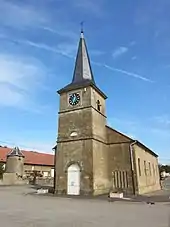
Pfarrkirche Saint-Willibrord
This article is issued from Wikipedia. The text is licensed under Creative Commons - Attribution - Sharealike. The authors of the article are listed here. Additional terms may apply for the media files, click on images to show image meta data.