Preutin-Higny
| Preutin-Higny | ||
|---|---|---|
|
| |
| Staat | Frankreich | |
| Region | Grand Est | |
| Département (Nr.) | Meurthe-et-Moselle (54) | |
| Arrondissement | Briey | |
| Kanton | Pays de Briey | |
| Gemeindeverband | Pays de l’Audunois et du Bassin de Landres | |
| Koordinaten | 49° 21′ N, 5° 47′ O | |
| Höhe | 272–367 m | |
| Fläche | 7,07 km² | |
| Einwohner | 146 (1. Januar 2019) | |
| Bevölkerungsdichte | 21 Einw./km² | |
| Postleitzahl | 54490 | |
| INSEE-Code | 54436 | |

Preutin-Higny ist eine französische Gemeinde mit 146 Einwohnern (Stand: 1. Januar 2019) im Département Meurthe-et-Moselle in der Region Grand Est (bis 2015 Lothringen). Die Gemeinde ist Teil des Arrondissements Briey sowie des Kantons Pays de Briey (bis 2015: Kanton Audun-le-Roman).
Lage
Preutin-Higny liegt etwa 33 Kilometer westlich von Thionville. Umgeben wird Preutin-Higny von den Nachbargemeinden Xivry-Circourt im Norden und Westen, Mercy-le-Haut im Norden und Nordosten, Murville im Osten, Landres im Süden sowie Domprix im Südwesten.
Bevölkerungsentwicklung
| Jahr | 1962 | 1968 | 1975 | 1982 | 1990 | 1999 | 2006 | 2013 |
| Einwohner | 174 | 171 | 121 | 101 | 125 | 133 | 130 | 140 |
| Quelle: Cassini und INSEE | ||||||||
Sehenswürdigkeiten
- Kirche La Nativité-de-la-Vierge in Preutin aus dem 12. Jahrhundert
- Kirche Saint-Gorgon in Higny
- Reste des Schlosses aus dem 17. Jahrhundert
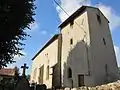 Kirche La Nativité-de-la-Vierge
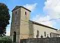 Kirche Saint-Gorgon
This article is issued from Wikipedia. The text is licensed under Creative Commons - Attribution - Sharealike. The authors of the article are listed here. Additional terms may apply for the media files, click on images to show image meta data.