Mairy-Mainville
| Mairy-Mainville | ||
|---|---|---|
|
| |
| Staat | Frankreich | |
| Region | Grand Est | |
| Département (Nr.) | Meurthe-et-Moselle (54) | |
| Arrondissement | Briey | |
| Kanton | Pays de Briey | |
| Gemeindeverband | Pays de l’Audunois et du Bassin de Landres | |
| Koordinaten | 49° 18′ N, 5° 50′ O | |
| Höhe | 237–325 m | |
| Fläche | 12,56 km² | |
| Einwohner | 561 (1. Januar 2019) | |
| Bevölkerungsdichte | 45 Einw./km² | |
| Postleitzahl | 54150 | |
| INSEE-Code | 54334 | |

Mairy-Mainville ist eine französische Gemeinde mit 945 Einwohnern (Stand: 1. Januar 2019) im Département Meurthe-et-Moselle in der Region Grand Est (vor 2016: Lothringen). Die Gemeinde gehört zum Arrondissement Briey und zum Kanton Pays de Briey.
Geographie
Mairy-Mainville liegt etwa 39 Kilometer südsüdwestlich von Luxemburg und 23 Kilometer westsüdwestlich von Thionville am Fluss Woigot. Umgeben wird Mairy-Mainville von den Nachbargemeinden Mont-Bonvillers im Norden, Anderny im Norden und Nordosten, Tucquegnieux im Osten, Anoux im Süden sowie Landres im Westen.
Bevölkerungsentwicklung
| Jahr | 1962 | 1968 | 1975 | 1982 | 1990 | 1999 | 2006 | 2019 |
|---|---|---|---|---|---|---|---|---|
| Einwohner | 615 | 572 | 531 | 456 | 468 | 479 | 536 | 561 |
| Quellen: Cassini und INSEE | ||||||||
Sehenswürdigkeiten
- Kirche Saint-Martin in Mairy aus dem 12. Jahrhundert, Monument historique
- Kirche Saint-Pierre in Mainville aus dem 13. Jahrhundert
- Kapelle Sainte-Barbe in Mainville aus dem 18. Jahrhundert
- Schloss Mairy, 1594 bis 1602 erbaut
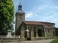 Kirche Saint-Martin
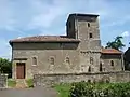 Kirche Saint-Pierre
 Kapelle Sainte-Barbe
This article is issued from Wikipedia. The text is licensed under Creative Commons - Attribution - Sharealike. The authors of the article are listed here. Additional terms may apply for the media files, click on images to show image meta data.