Montigny-sur-Chiers
| Montigny-sur-Chiers | ||
|---|---|---|
|
| |
| Staat | Frankreich | |
| Region | Grand Est | |
| Département (Nr.) | Meurthe-et-Moselle (54) | |
| Arrondissement | Briey | |
| Kanton | Mont-Saint-Martin | |
| Gemeindeverband | Terre Lorraine du Longuyonnais | |
| Koordinaten | 49° 29′ N, 5° 40′ O | |
| Höhe | 217–351 m | |
| Fläche | 9,43 km² | |
| Einwohner | 473 (1. Januar 2019) | |
| Bevölkerungsdichte | 50 Einw./km² | |
| Postleitzahl | 54870 | |
| INSEE-Code | 54378 | |
_%C3%A9coles_et_mairie.JPG.webp) Rathaus (Mairie) von Montigny-sur-Chiers | ||

Montigny-sur-Chiers ist eine französische Gemeinde mit 473 Einwohnern (Stand: 1. Januar 2019) im Département Meurthe-et-Moselle in der Region Grand Est (bis 2015 Lothringen). Sie gehört zum Arrondissement Briey und zum Kanton Mont-Saint-Martin.
Zur Gemeinde gehört die Ortschaft Fermont.
Geografie
Montigny-sur-Chiers liegt etwa 80 Kilometer nordwestlich von Metz am Chiers. Nachbargemeinden von Montigny-sur-Chiers sind Fresnois-la-Montagne im Norden, Villers-la-Chèvre im Nordosten, Cons-la-Grandville im Nordosten und Osten, Ugny im Osten und Südosten, Beuveille im Süden sowie Viviers-sur-Chiers im Südwesten und SWesten.
Bevölkerungsentwicklung
| Jahr | 1962 | 1968 | 1975 | 1982 | 1990 | 1999 | 2006 | 2019 |
| Einwohner | 665 | 622 | 574 | 511 | 507 | 443 | 465 | 473 |
| Quellen: Cassini und INSEE | ||||||||
Sehenswürdigkeiten
- Kirche Saint-Denys aus dem 13. Jahrhundert
- Kirche Saint-Privat in Fermont aus dem Jahre 1734
- Kapelle La Roche
- Festung von Fermont
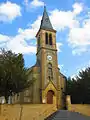 Kirche Saint-Denys
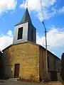 Kirche Saint-Privat
This article is issued from Wikipedia. The text is licensed under Creative Commons - Attribution - Sharealike. The authors of the article are listed here. Additional terms may apply for the media files, click on images to show image meta data.