Kanton Longuyon
Der Kanton Longuyon war bis 2015 ein französischer Kanton im Arrondissement Briey, im Département Meurthe-et-Moselle und in der Region Lothringen; sein Hauptort war Longuyon. Letzter Vertreter im Generalrat des Départements war von 1976 bis 2015 Pierre Mersch.
| Ehemaliger Kanton Longuyon | |
|---|---|
| Region | Lothringen |
| Département | Meurthe-et-Moselle |
| Arrondissement | Briey |
| Hauptort | Longuyon |
| Auflösungsdatum | 29. März 2015 |
| Einwohner | 14.810 (1. Jan. 2012) |
| Bevölkerungsdichte | 69 Einw./km² |
| Fläche | 214.43 km² |
| Gemeinden | 23 |
| INSEE-Code | 5415 |
Der Kanton Longuyon war 214,43 km² groß und hatte 14.592 Einwohner (Stand 2006), was einer Bevölkerungsdichte von 68 Einwohnern pro km² entsprach. Er lag im Mittel auf 252 Meter über dem Meeresspiegel, zwischen 188 m in Othe und 403 m in Tellancourt.
Lage
Der Kanton lag ganz im Nordwesten des Départements Meurthe-et-Moselle.
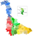 Lage des Kantons Longuyon im Département Meurthe-et-Moselle
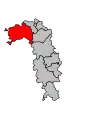 Lage des Kantons Longuyon im Arrondissement Briey
Gemeinden
Der Kanton bestand aus 23 Gemeinden:
| Gemeinde | Einwohner Jahr | Fläche km² | Bevölkerungsdichte | Code INSEE | Postleitzahl |
|---|---|---|---|---|---|
| Allondrelle-la-Malmaison | 617 (2013) | 13,61 | 45 Einw./km² | 54011 | 54260 |
| Beuveille | 785 (2013) | 11,90 | 66 Einw./km² | 54067 | 54620 |
| Charency-Vezin | 657 (2013) | 14,79 | 44 Einw./km² | 54118 | 54260 |
| Colmey | 264 (2013) | 9,90 | 27 Einw./km² | 54134 | 54260 |
| Cons-la-Grandville | 579 (2013) | 8,25 | 70 Einw./km² | 54137 | 54260 |
| Doncourt-lès-Longuyon | 308 (2013) | 5,62 | 55 Einw./km² | 54172 | 54870 |
| Épiez-sur-Chiers | 181 (2013) | 5,19 | 35 Einw./km² | 54178 | 54620 |
| Fresnois-la-Montagne | 412 (2013) | 8,59 | 48 Einw./km² | 54212 | 54260 |
| Grand-Failly | 305 (2013) | 21,87 | 14 Einw./km² | 54236 | 54260 |
| Han-devant-Pierrepont | 151 (2013) | 4,96 | 30 Einw./km² | 54602 | 54620 |
| Longuyon | 5.459 (2013) | 29,70 | 184 Einw./km² | 54322 | 54260 |
| Montigny-sur-Chiers | 490 (2013) | 9,36 | 52 Einw./km² | 54378 | 54870 |
| Othe | 30 (2013) | 2,97 | 10 Einw./km² | 54412 | 54260 |
| Petit-Failly | 86 (2013) | 8,12 | 11 Einw./km² | 54420 | 54260 |
| Pierrepont | 881 (2013) | 7,02 | 125 Einw./km² | 54428 | 54620 |
| Saint-Jean-lès-Longuyon | 408 (2013) | 4,21 | 97 Einw./km² | 54476 | 54260 |
| Saint-Pancré | 324 (2013) | 6,13 | 53 Einw./km² | 54485 | 54730 |
| Tellancourt | 561 (2013) | 3,76 | 149 Einw./km² | 54514 | 54260 |
| Ugny | 744 (2013) | 9,14 | 81 Einw./km² | 54537 | 54870 |
| Villers-la-Chèvre | 570 (2013) | 4,02 | 142 Einw./km² | 54574 | 54870 |
| Villers-le-Rond | 96 (2013) | 4,45 | 22 Einw./km² | 54576 | 54260 |
| Villette | 183 (2013) | 4,63 | 40 Einw./km² | 54582 | 54260 |
| Viviers-sur-Chiers | 634 (2013) | 16,24 | 39 Einw./km² | 54590 | 54260 |
Bevölkerungsentwicklung
| 1962 | 1968 | 1975 | 1982 | 1990 | 1999 | 2006 | 2012 |
|---|---|---|---|---|---|---|---|
| 12.659 | 15.343 | 16.126 | 15.455 | 13.990 | 14.072 | 14.592 | 14.810 |
This article is issued from Wikipedia. The text is licensed under Creative Commons - Attribution - Sharealike. The authors of the article are listed here. Additional terms may apply for the media files, click on images to show image meta data.