Mont-Bonvillers
| Mont-Bonvillers | ||
|---|---|---|
|
| |
| Staat | Frankreich | |
| Region | Grand Est | |
| Département (Nr.) | Meurthe-et-Moselle (54) | |
| Arrondissement | Briey | |
| Kanton | Pays de Briey | |
| Gemeindeverband | Pays de l’Audunois et du Bassin de Landres | |
| Koordinaten | 49° 20′ N, 5° 50′ O | |
| Höhe | 270–361 m | |
| Fläche | 7,03 km² | |
| Einwohner | 945 (1. Januar 2019) | |
| Bevölkerungsdichte | 134 Einw./km² | |
| Postleitzahl | 54111 | |
| INSEE-Code | 54084 | |

Mont-Bonvillers ist eine französische Gemeinde mit 945 Einwohnern (Stand: 1. Januar 2019) im Département Meurthe-et-Moselle in der Region Grand Est (vor 2016: Lothringen). Die Gemeinde gehört zum Arrondissement Briey und zum Kanton Pays de Briey.
Geographie
Mont-Bonvillers liegt etwa 39 Kilometer südsüdwestlich von Luxemburg und 25 Kilometer westsüdwestlich von Thionville. Umgeben wird Mont-Bonvillers von den Nachbargemeinden Murville im Nordwesten und Norden, Malavillers im Nordosten, Anderny im Osten, Mairy-Mainville im Süden sowie Landres im Westen.
Bevölkerungsentwicklung
| Jahr | 1962 | 1968 | 1975 | 1982 | 1990 | 1999 | 2006 | 2019 |
|---|---|---|---|---|---|---|---|---|
| Einwohner | 1795 | 1064 | 1241 | 1081 | 1010 | 955 | 960 | 845 |
| Quellen: Cassini und INSEE | ||||||||
Sehenswürdigkeiten
- Kirche Saint-Julien in Mont aus dem 12. Jahrhundert, seit 1933 Monument historique
- Kirche Saint-Étienne-et-Saint-Thibault in Bonvillers aus dem 12. Jahrhundert, seit 1992 Monument historique
- namenlose Kapelle
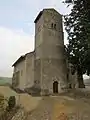 Kirche Saint-Julien
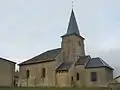 Kirche Saint-Étienne-et-Saint-Thibault
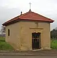 Kapelle in Mont-Bonvillers
This article is issued from Wikipedia. The text is licensed under Creative Commons - Attribution - Sharealike. The authors of the article are listed here. Additional terms may apply for the media files, click on images to show image meta data.