Allondrelle-la-Malmaison
| Allondrelle-la-Malmaison | ||
|---|---|---|
|
| |
| Staat | Frankreich | |
| Region | Grand Est | |
| Département (Nr.) | Meurthe-et-Moselle (54) | |
| Arrondissement | Briey | |
| Kanton | Mont-Saint-Martin | |
| Gemeindeverband | Terre Lorraine du Longuyonnais | |
| Koordinaten | 49° 31′ N, 5° 34′ O | |
| Höhe | 230–396 m | |
| Fläche | 13,58 km² | |
| Einwohner | 654 (1. Januar 2019) | |
| Bevölkerungsdichte | 48 Einw./km² | |
| Postleitzahl | 54260 | |
| INSEE-Code | 54011 | |

Allondrelle-la-Malmaison ist eine französische Gemeinde mit 654 Einwohnern (Stand: 1. Januar 2019) im Département Meurthe-et-Moselle in der Region Grand Est (bis 2015 Lothringen). Sie gehört zum Arrondissement Briey und zum Kanton Mont-Saint-Martin.
Geografie
Allondrelle-la-Malmaison liegt etwa 80 Kilometer nordwestlich von Metz an der Grenze zu Belgien. Nachbargemeinden von Allondrelle-la-Malmaison sind Virton (Belgien) im Norden und Osten, Longuyon im Südosten und Süden sowie Charency-Vezin im Südwesten und Westen.
Bevölkerungsentwicklung
| Jahr | 1962 | 1968 | 1975 | 1982 | 1990 | 1999 | 2006 | 2019 |
| Einwohner | 581 | 560 | 513 | 483 | 481 | 519 | 603 | 654 |
| Quellen: Cassini und INSEE | ||||||||
Sehenswürdigkeiten
- Merowingernekropole
- Kirche Saint-Pierre in Allondrelle
- Kirche Saint-Nicolas in La Malmaison, 1867 erbaut
- Kapellen Sainte-Reigne und von L'Ange-Gardien
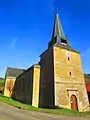 Kirche Saint-Pierre
.jpg.webp) Kirche Saint-Nicolas
Kirche Saint-Nicolas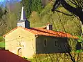 Kapelle Sainte-Reine
This article is issued from Wikipedia. The text is licensed under Creative Commons - Attribution - Sharealike. The authors of the article are listed here. Additional terms may apply for the media files, click on images to show image meta data.