Colmey
| Colmey | ||
|---|---|---|
|
| |
| Staat | Frankreich | |
| Region | Grand Est | |
| Département (Nr.) | Meurthe-et-Moselle (54) | |
| Arrondissement | Briey | |
| Kanton | Mont-Saint-Martin | |
| Gemeindeverband | Terre Lorraine du Longuyonnais | |
| Koordinaten | 49° 28′ N, 5° 33′ O | |
| Höhe | 197–352 m | |
| Fläche | 9,95 km² | |
| Einwohner | 244 (1. Januar 2019) | |
| Bevölkerungsdichte | 25 Einw./km² | |
| Postleitzahl | 54260 | |
| INSEE-Code | 54134 | |

Colmey ist eine französische Gemeinde mit 244 Einwohnern (Stand: 1. Januar 2019) im Département Meurthe-et-Moselle in der Region Grand Est (bis 2015 Lothringen). Sie gehört zum Arrondissement Briey und zum Kanton Mont-Saint-Martin.
Geografie
Colmey liegt etwa 80 Kilometer nordwestlich von Metz am Chiers. Nachbargemeinden von Colmey sind Villette im Norden, Longuyon im Nordosten und Osten, Grand-Failly im Süden, Petit-Failly im Südwesten, Saint-Jean-lès-Longuyon im Westen sowie Charency-Vezin im Nordwesten.
Bevölkerungsentwicklung
| Jahr | 1962 | 1968 | 1975 | 1982 | 1990 | 1999 | 2006 | 2019 |
| Einwohner | 350 | 341 | 315 | 321 | 273 | 245 | 275 | 244 |
| Quellen: Cassini und INSEE | ||||||||
Sehenswürdigkeiten
- Kirche L'Assomption-de-la-Vierge, 1878 wieder errichtet
- Kirche Saint-Hubert in Flabeuville aus dem 16. Jahrhundert
- Kapelle Saint-Hubert, früheres Ossarium, aus dem 15./16. Jahrhundert, seit 1990 Monument historique
- Kapelle Saint-Joseph
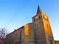 Kirche L'Assomption-de-la-Vierge
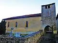 Kirche Saint-Hubert
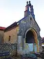 Kapelle Saint-Hubert
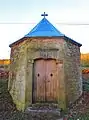 Kapelle Saint-Joseph
This article is issued from Wikipedia. The text is licensed under Creative Commons - Attribution - Sharealike. The authors of the article are listed here. Additional terms may apply for the media files, click on images to show image meta data.