Saint-Supplet
| Saint-Supplet | ||
|---|---|---|
|
| |
| Staat | Frankreich | |
| Region | Grand Est | |
| Département (Nr.) | Meurthe-et-Moselle (54) | |
| Arrondissement | Briey | |
| Kanton | Mont-Saint-Martin | |
| Gemeindeverband | Terre Lorraine du Longuyonnais | |
| Koordinaten | 49° 23′ N, 5° 44′ O | |
| Höhe | 243–323 m | |
| Fläche | 7,36 km² | |
| Einwohner | 148 (1. Januar 2019) | |
| Bevölkerungsdichte | 20 Einw./km² | |
| Postleitzahl | 54620 | |
| INSEE-Code | 54489 | |
| Website | http://www.saint-supplet.fr/ | |
_mairie.JPG.webp) Rathaus (Mairie) in Saint-Supplet | ||

Saint-Supplet ist eine französische Gemeinde mit 148 Einwohnern (Stand: 1. Januar 2019) im Département Meurthe-et-Moselle in der Region Grand Est (bis 2015 Lothringen). Die Gemeinde gehört zum Arrondissement Briey und zum Kanton Mont-Saint-Martin (bis 2015: Kanton Audun-le-Roman).
Geographie
Saint-Supplet liegt etwa 50 Kilometer südwestlich von Luxemburg. Umgeben wird Saint-Supplet von den Nachbargemeinden Han-devant-Pierrepont im Norden, Mercy-le-Bas im Osten, Xivry-Circourt im Süden und Südosten, Spincourt im Süden und Südwesten sowie Saint-Pierrevillers im Westen.
Bevölkerungsentwicklung
| Jahr | 1962 | 1968 | 1975 | 1982 | 1990 | 1999 | 2006 | 2013 |
|---|---|---|---|---|---|---|---|---|
| Einwohner | 296 | 230 | 207 | 200 | 186 | 165 | 173 | 161 |
| Quelle: Cassini und INSEE | ||||||||
Sehenswürdigkeiten
- Kirche Saint-Sulpice aus dem 14./15. Jahrhundert
- Grabeskapelle von General Georges-Louis Guinot im ehemaligen Beinhaus aus dem 16. Jahrhundert
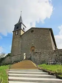
Kirche Saint-Sulpice
This article is issued from Wikipedia. The text is licensed under Creative Commons - Attribution - Sharealike. The authors of the article are listed here. Additional terms may apply for the media files, click on images to show image meta data.