Kanton Conflans-en-Jarnisy
Der Kanton Conflans-en-Jarnisy war bis 2015 ein französischer Kanton im Arrondissement Briey, im Département Meurthe-et-Moselle und in der Region Lothringen; sein Hauptort war Conflans-en-Jarnisy. Letzter Vertreter im Generalrat des Départements war von 2011 bis 2015 Olivier Tritz.
| Ehemaliger Kanton Conflans-en-Jarnisy | |
|---|---|
| Region | Lothringen |
| Département | Meurthe-et-Moselle |
| Arrondissement | Briey |
| Hauptort | Conflans-en-Jarnisy |
| Auflösungsdatum | 29. März 2015 |
| Einwohner | 19.232 (1. Jan. 2012) |
| Bevölkerungsdichte | 83 Einw./km² |
| Fläche | 231.05 km² |
| Gemeinden | 25 |
| INSEE-Code | 5411 |
Der Kanton Conflans-en-Jarnisy war 23.105 Hektar (231,05 km²) groß und hatte (1999) 18.369 Einwohner, was einer Bevölkerungsdichte von 79,5 Einwohnern pro km² entsprach. Er lag im Mittel auf 226 Meter über dem Meeresspiegel, zwischen 183 m in Giraumont und 314 m in Saint-Marcel.
Lage
Der Kanton lag im Norden des Départements Meurthe-et-Moselle an dessen Ostgrenze.
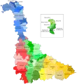 Lage des Kantons Conflans-en-Jarnisy im Département Meurthe-et-Moselle
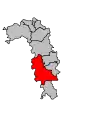 Lage des Kantons Conflans-en-Jarnisy im Arrondissement Briey
Gemeinden
Der Kanton bestand aus 25 Gemeinden:
| Gemeinde | Einwohner Jahr | Fläche km² | Bevölkerungsdichte | Code INSEE | Postleitzahl |
|---|---|---|---|---|---|
| Abbéville-lès-Conflans | 225 (2013) | 7,73 | 29 Einw./km² | 54002 | 54800 |
| Affléville | 181 (2013) | 9,42 | 19 Einw./km² | 54004 | 54800 |
| Allamont | 154 (2013) | 9,06 | 17 Einw./km² | 54009 | 54800 |
| Béchamps | 90 (2013) | 9,28 | 10 Einw./km² | 54058 | 54800 |
| Boncourt | 196 (2013) | 6,73 | 29 Einw./km² | 54082 | 54800 |
| Brainville | 158 (2013) | 9,92 | 16 Einw./km² | 54093 | 54800 |
| Bruville | 237 (2013) | 10,81 | 22 Einw./km² | 54103 | 54800 |
| Conflans-en-Jarnisy | 2.375 (2013) | 8,71 | 273 Einw./km² | 54136 | 54800 |
| Doncourt-lès-Conflans | 1.202 (2013) | 7,34 | 164 Einw./km² | 54171 | 54800 |
| Fléville-Lixières | 294 (2013) | 14,38 | 20 Einw./km² | 54198 | 54150 |
| Friauville | 367 (2013) | 6,34 | 58 Einw./km² | 54213 | 54800 |
| Giraumont | 1.374 (2013) | 7,63 | 180 Einw./km² | 54227 | 54780 |
| Gondrecourt-Aix | 182 (2013) | 12,28 | 15 Einw./km² | 54231 | 54800 |
| Hannonville-Suzémont | 273 (2013) | 8,68 | 31 Einw./km² | 54249 | 54800 |
| Jarny | 8.383 (2013) | 15,60 | 537 Einw./km² | 54273 | 54800 |
| Jeandelize | 383 (2013) | 6,75 | 57 Einw./km² | 54277 | 54800 |
| Labry | 1.565 (2013) | 5,95 | 263 Einw./km² | 54286 | 54800 |
| Mouaville | 102 (2013) | 8,44 | 12 Einw./km² | 54389 | 54800 |
| Norroy-le-Sec | 412 (2013) | 13,77 | 30 Einw./km² | 54402 | 54150 |
| Olley | 261 (2013) | 9,48 | 28 Einw./km² | 54408 | 54800 |
| Ozerailles | 146 (2013) | 6,32 | 23 Einw./km² | 54413 | 54150 |
| Puxe | 105 (2013) | 5,89 | 18 Einw./km² | 54440 | 54800 |
| Saint-Marcel | 141 (2013) | 11,35 | 12 Einw./km² | 54478 | 54800 |
| Thumeréville | 91 (2013) | 7,89 | 12 Einw./km² | 54524 | 54800 |
| Ville-sur-Yron | 300 (2013) | 11,30 | 27 Einw./km² | 54581 | 54800 |
Bevölkerungsentwicklung
| 1962 | 1968 | 1975 | 1982 | 1990 | 1999 | 2006 | 2012 |
|---|---|---|---|---|---|---|---|
| 19.026 | 19.879 | 18.761 | 18.422 | 18.409 | 18.369 | 19.112 | 19.232 |
This article is issued from Wikipedia. The text is licensed under Creative Commons - Attribution - Sharealike. The authors of the article are listed here. Additional terms may apply for the media files, click on images to show image meta data.