Kanton Colombey-les-Belles
Der französische Kanton Colombey-les-Belles war bis 2015 ein Wahlkreis im Arrondissement Toul im Département Meurthe-et-Moselle. Letzter Vertreter im Generalrat des Départements war von 1978 bis 2015 Michel Dinet. Hauptort des Kantons war die Gemeinde Colombey-les-Belles. Der Kanton hatte 7.634 Einwohner (Stand 2006) auf 298,89 km².
| Ehemaliger Kanton Colombey-les-Belles | |
|---|---|
| Region | Lothringen |
| Département | Meurthe-et-Moselle |
| Arrondissement | Toul |
| Hauptort | Colombey-les-Belles |
| Auflösungsdatum | 29. März 2015 |
| Einwohner | 8.035 (1. Jan. 2012) |
| Bevölkerungsdichte | 27 Einw./km² |
| Fläche | 298.89 km² |
| Gemeinden | 31 |
| INSEE-Code | 5410 |
Lage
Der Kanton lag im Südwesten des Départements Meurthe-et-Moselle.
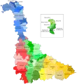 Lage des Kantons Colombey-les-Belles im Département Meurthe-et-Moselle
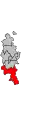 Lage des Kantons Colombey-les-Belles im Arrondissement Toul
Gemeinden
Der Kanton umfasste 31 Gemeinden:
| Gemeinde | Einwohner Jahr | Fläche km² | Bevölkerungsdichte | Code INSEE | Postleitzahl |
|---|---|---|---|---|---|
| Aboncourt | 106 (2013) | 6,93 | 15 Einw./km² | 54003 | 54115 |
| Allain | 463 (2013) | 16,48 | 28 Einw./km² | 54008 | 54170 |
| Allamps | 531 (2013) | 7,21 | 74 Einw./km² | 54010 | 54112 |
| Bagneux | 155 (2013) | 8,60 | 18 Einw./km² | 54041 | 54170 |
| Barisey-au-Plain | 418 (2013) | 10,85 | 39 Einw./km² | 54046 | 54170 |
| Barisey-la-Côte | 214 (2013) | 3,87 | 55 Einw./km² | 54047 | 54170 |
| Battigny | 126 (2013) | 6,41 | 20 Einw./km² | 54052 | 54115 |
| Beuvezin | 105 (2013) | 7,72 | 14 Einw./km² | 54068 | 54115 |
| Colombey-les-Belles | 1.431 (2013) | 17,59 | 81 Einw./km² | 54135 | 54170 |
| Courcelles | 108 (2013) | 4,31 | 25 Einw./km² | 54140 | 54930 |
| Crépey | 380 (2013) | 20,90 | 18 Einw./km² | 54143 | 54170 |
| Dolcourt | 117 (2013) | 6,19 | 19 Einw./km² | 54158 | 54170 |
| Favières | 609 (2013) | 29,50 | 21 Einw./km² | 54189 | 54115 |
| Fécocourt | 112 (2013) | 7,86 | 14 Einw./km² | 54190 | 54115 |
| Gélaucourt | 60 (2013) | 2,26 | 27 Einw./km² | 54218 | 54115 |
| Gémonville | 74 (2013) | 9,03 | 8 Einw./km² | 54220 | 54115 |
| Germiny | 184 (2013) | 11,85 | 16 Einw./km² | 54223 | 54170 |
| Gibeaumeix | 168 (2013) | 7,80 | 22 Einw./km² | 54226 | 54112 |
| Grimonviller | 109 (2013) | 4,78 | 23 Einw./km² | 54237 | 54115 |
| Mont-l’Étroit | 100 (2013) | 6,42 | 16 Einw./km² | 54379 | 54170 |
| Pulney | 64 (2013) | 4,40 | 15 Einw./km² | 54438 | 54115 |
| Saulxerotte | 97 (2013) | 3,15 | 31 Einw./km² | 54494 | 54115 |
| Saulxures-lès-Vannes | 363 (2013) | 18,04 | 20 Einw./km² | 54496 | 54170 |
| Selaincourt | 178 (2013) | 10,86 | 16 Einw./km² | 54500 | 54170 |
| Thuilley-aux-Groseilles | 474 (2013) | 9,12 | 52 Einw./km² | 54523 | 54170 |
| Tramont-Émy | 34 (2013) | 3,91 | 9 Einw./km² | 54529 | 54115 |
| Tramont-Lassus | 83 (2013) | 5,76 | 14 Einw./km² | 54530 | 54115 |
| Tramont-Saint-André | 57 (2013) | 6,88 | 8 Einw./km² | 54531 | 54115 |
| Uruffe | 386 (2013) | 13,05 | 30 Einw./km² | 54538 | 54112 |
| Vandeléville | 208 (2013) | 9,86 | 21 Einw./km² | 54545 | 54115 |
| Vannes-le-Châtel | 579 (2013) | 17,30 | 33 Einw./km² | 54548 | 54112 |
Bevölkerungsentwicklung
| 1962 | 1968 | 1975 | 1982 | 1990 | 1999 | 2006 | 2012 |
|---|---|---|---|---|---|---|---|
| 6.405 | 6.950 | 6.273 | 6.489 | 6.566 | 6.954 | 7.634 | 8.035 |
This article is issued from Wikipedia. The text is licensed under Creative Commons - Attribution - Sharealike. The authors of the article are listed here. Additional terms may apply for the media files, click on images to show image meta data.