Kanton Domèvre-en-Haye
Der Kanton Domèvre-en-Haye war bis 2015 ein französischer Kanton im Arrondissement Toul, im Département Meurthe-et-Moselle und in der Region Lothringen; sein Hauptort war Domèvre-en-Haye. Letzter Vertreter im Generalrat des Départements war von 1994 bis 2015 Jean Loctin.
| Ehemaliger Kanton Domèvre-en-Haye | |
|---|---|
| Region | Lothringen |
| Département | Meurthe-et-Moselle |
| Arrondissement | Toul |
| Hauptort | Domèvre-en-Haye |
| Auflösungsdatum | 29. März 2015 |
| Einwohner | 13.736 (1. Jan. 2012) |
| Bevölkerungsdichte | 51 Einw./km² |
| Fläche | 268.83 km² |
| Gemeinden | 27 |
| INSEE-Code | 5412 |
Der Kanton Domèvre-en-Haye war 26.883 Hektar (268,83 km²) groß und hatte (1999) 13.233 Einwohner, was einer Bevölkerungsdichte von 49 Einwohnern pro km² entsprach. Er lag im Mittel auf 243 Meter über dem Meeresspiegel, zwischen 187 m in Liverdun und 354 m in Mamey.
Lage
Der Kanton lag im Zentrum des Départements Meurthe-et-Moselle an dessen Westgrenze.
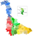 Lage des Kantons Domèvre-en-Haye im Département Meurthe-et-Moselle
 Lage des Kantons Domèvre-en-Haye im Arrondissement Toul
Gemeinden
Der Kanton bestand aus 27 Gemeinden:
| Gemeinde | Einwohner Jahr | Fläche km² | Bevölkerungsdichte | Code INSEE | Postleitzahl |
|---|---|---|---|---|---|
| Andilly | 285 (2013) | 7,12 | 40 Einw./km² | 54016 | 54200 |
| Ansauville | 84 (2013) | 6,97 | 12 Einw./km² | 54019 | 54470 |
| Avrainville | 198 (2013) | 9,73 | 20 Einw./km² | 54034 | 54385 |
| Beaumont | 65 (2013) | 3,11 | 21 Einw./km² | 54057 | 54470 |
| Bernécourt | 186 (2013) | 9,38 | 20 Einw./km² | 54063 | 54470 |
| Domèvre-en-Haye | 413 (2013) | 8,46 | 49 Einw./km² | 54160 | 54385 |
| Francheville | 283 (2013) | 10,94 | 26 Einw./km² | 54208 | 54200 |
| Gézoncourt | 170 (2013) | 5,34 | 32 Einw./km² | 54225 | 54380 |
| Griscourt | 125 (2013) | 3,74 | 33 Einw./km² | 54239 | 54380 |
| Grosrouvres | 54 (2013) | 4,61 | 12 Einw./km² | 54240 | 54470 |
| Hamonville | 94 (2013) | 6,66 | 14 Einw./km² | 54248 | 54470 |
| Jaillon | 450 (2013) | 7,47 | 60 Einw./km² | 54272 | 54200 |
| Liverdun | 5.960 (2013) | 25,25 | 236 Einw./km² | 54318 | 54460 |
| Mamey | 341 (2013) | 7,56 | 45 Einw./km² | 54340 | 54470 |
| Mandres-aux-Quatre-Tours | 178 (2013) | 10,24 | 17 Einw./km² | 54343 | 54470 |
| Manoncourt-en-Woëvre | 250 (2013) | 10,56 | 24 Einw./km² | 54346 | 54385 |
| Manonville | 243 (2013) | 9,43 | 26 Einw./km² | 54348 | 54385 |
| Martincourt | 95 (2013) | 10,66 | 9 Einw./km² | 54355 | 54380 |
| Minorville | 240 (2013) | 12,65 | 19 Einw./km² | 54370 | 54385 |
| Noviant-aux-Prés | 265 (2013) | 11,19 | 24 Einw./km² | 54404 | 54385 |
| Rogéville | 176 (2013) | 6,94 | 25 Einw./km² | 54460 | 54380 |
| Rosières-en-Haye | 245 (2013) | 10,74 | 23 Einw./km² | 54463 | 54385 |
| Royaumeix | 346 (2013) | 21,57 | 16 Einw./km² | 54466 | 54200 |
| Tremblecourt | 199 (2013) | 6,08 | 33 Einw./km² | 54532 | 54385 |
| Velaine-en-Haye | 1.671 (2013) | 17,87 | 94 Einw./km² | 54557 | 54840 |
| Villers-en-Haye | 185 (2013) | 7,29 | 25 Einw./km² | 54573 | 54380 |
| Villey-Saint-Étienne | 1.109 (2013) | 17,29 | 64 Einw./km² | 54584 | 54200 |
Bevölkerungsentwicklung
| 1962 | 1968 | 1975 | 1982 | 1990 | 1999 | 2006 | 2012 |
|---|---|---|---|---|---|---|---|
| 7.929 | 8.825 | 10.028 | 11.887 | 12.838 | 13.233 | 13.373 | 13.736 |
This article is issued from Wikipedia. The text is licensed under Creative Commons - Attribution - Sharealike. The authors of the article are listed here. Additional terms may apply for the media files, click on images to show image meta data.