Kanton Dieulouard
Der Kanton Dieulouard war bis 2015 ein französischer Kanton im Arrondissement Nancy, im Département Meurthe-et-Moselle und in der Region Lothringen; sein Hauptort war Dieulouard. Letzter Vertreter im Generalrat des Départements war von 2001 bis 2015 Yvon Biston.
| Ehemaliger Kanton Dieulouard | |
|---|---|
| Region | Lothringen |
| Département | Meurthe-et-Moselle |
| Arrondissement | Nancy |
| Hauptort | Dieulouard |
| Auflösungsdatum | 29. März 2015 |
| Einwohner | 19.508 (1. Jan. 2012) |
| Bevölkerungsdichte | 161 Einw./km² |
| Fläche | 121.21 km² |
| Gemeinden | 11 |
| INSEE-Code | 5441 |
Geographie
Das Gebiet des Kantons erstreckte sich entlang des linken Moselufers und über die westlich ansteigenden Hänge der Côtes de Moselle. Es schloss die Stadt Pont-à-Mousson halbkreisförmig ein.
Lage
Der Kanton lag im Zentrum des Départements Meurthe-et-Moselle.
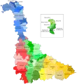 Lage des Kantons Dieulouard im Département Meurthe-et-Moselle
 Lage des Kantons Dieulouard im Arrondissement Nancy
Geschichte
Der Kanton wurde 1948 als Ausgliederung des Kantons Pont-à-Mousson gebildet.
Gemeinden
Der Kanton bestand aus elf Gemeinden:
| Gemeinde | Einwohner Jahr | Fläche km² | Bevölkerungsdichte | Code INSEE | Postleitzahl |
|---|---|---|---|---|---|
| Blénod-lès-Pont-à-Mousson | 4.420 (2013) | 9,58 | 461 Einw./km² | 54079 | 54700 |
| Dieulouard | 4.572 (2013) | 17,69 | 258 Einw./km² | 54157 | 54380 |
| Fey-en-Haye | 75 (2013) | 7,05 | 11 Einw./km² | 54193 | 54470 |
| Jezainville | 942 (2013) | 18,19 | 52 Einw./km² | 54279 | 54700 |
| Maidières | 1.507 (2013) | 1,81 | 833 Einw./km² | 54332 | 54700 |
| Montauville | 1.143 (2013) | 16,19 | 71 Einw./km² | 54375 | 54700 |
| Norroy-lès-Pont-à-Mousson | 1.248 (2013) | 5,89 | 212 Einw./km² | 54403 | 54700 |
| Pagny-sur-Moselle | 4.095 (2013) | 11,20 | 366 Einw./km² | 54415 | 54530 |
| Prény | 370 (2013) | 15,09 | 25 Einw./km² | 54435 | 54530 |
| Vandières | 921 (2013) | 12,35 | 75 Einw./km² | 54546 | 54121 |
| Villers-sous-Prény | 348 (2013) | 6,17 | 56 Einw./km² | 54579 | 54700 |
Bevölkerungsentwicklung
| 1962 | 1968 | 1975 | 1982 | 1990 | 1999 | 2006 | 2012 |
|---|---|---|---|---|---|---|---|
| 15.377 | 17.583 | 18.222 | 19.005 | 19.833 | 19.845 | 19.703 | 19.508 |
This article is issued from Wikipedia. The text is licensed under Creative Commons - Attribution - Sharealike. The authors of the article are listed here. Additional terms may apply for the media files, click on images to show image meta data.