Kanton Haroué
Der Kanton Haroué war bis 2015 ein französischer Wahlkreis im Arrondissement Nancy, im Département Meurthe-et-Moselle und in der Region Lothringen; sein Hauptort war Haroué. Letzter Vertreter im Generalrat des Départements war von 1998 bis 2015 André Barbier.
| Ehemaliger Kanton Haroué | |
|---|---|
| Region | Lothringen |
| Département | Meurthe-et-Moselle |
| Arrondissement | Nancy |
| Hauptort | Haroué |
| Auflösungsdatum | 29. März 2015 |
| Einwohner | 9.105 (1. Jan. 2012) |
| Bevölkerungsdichte | 46 Einw./km² |
| Fläche | 199.75 km² |
| Gemeinden | 30 |
| INSEE-Code | 5414 |
Geografie
Der Kanton Haroué war 199,75 km² groß und hatte (1999) 8.062 Einwohner.
Lage
Der Kanton lag im Süden des Départements Meurthe-et-Moselle an dessen Südgrenze.
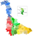 Lage des Kantons Haroué im Département Meurthe-et-Moselle
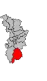 Lage des Kantons Haroué im Arrondissement Nancy
Gemeinden
Der Kanton bestand aus 30 Gemeinden:
| Gemeinde | Einwohner Jahr | Fläche km² | Bevölkerungsdichte | Code INSEE | Postleitzahl |
|---|---|---|---|---|---|
| Affracourt | 108 (2013) | 5,56 | 19 Einw./km² | 54005 | 54740 |
| Bainville-aux-Miroirs | 335 (2013) | 6,76 | 50 Einw./km² | 54042 | 54290 |
| Benney | 630 (2013) | 18,48 | 34 Einw./km² | 54062 | 54740 |
| Bouzanville | 62 (2013) | 5,82 | 11 Einw./km² | 54092 | 54930 |
| Bralleville | 182 (2013) | 4,39 | 41 Einw./km² | 54094 | 54740 |
| Ceintrey | 913 (2013) | 11,00 | 83 Einw./km² | 54109 | 54134 |
| Crantenoy | 141 (2013) | 5,28 | 27 Einw./km² | 54142 | 54740 |
| Crévéchamps | 356 (2013) | 4,86 | 73 Einw./km² | 54144 | 54290 |
| Diarville | 520 (2013) | 11,03 | 47 Einw./km² | 54156 | 54930 |
| Gerbécourt-et-Haplemont | 218 (2013) | 5,26 | 41 Einw./km² | 54221 | 54740 |
| Germonville | 115 (2013) | 5,21 | 22 Einw./km² | 54224 | 54740 |
| Gripport | 266 (2013) | 5,74 | 46 Einw./km² | 54238 | 54290 |
| Haroué | 462 (2013) | 4,14 | 112 Einw./km² | 54252 | 54740 |
| Housséville | 175 (2013) | 5,33 | 33 Einw./km² | 54268 | 54930 |
| Jevoncourt | 88 (2013) | 3,29 | 27 Einw./km² | 54278 | 54740 |
| Laneuveville-devant-Bayon | 238 (2013) | 5,75 | 41 Einw./km² | 54299 | 54740 |
| Lebeuville | 173 (2013) | 6,22 | 28 Einw./km² | 54307 | 54740 |
| Lemainville | 363 (2013) | 4,75 | 76 Einw./km² | 54309 | 54740 |
| Leménil-Mitry | 3 (2013) | 3,43 | 1 Einw./km² | 54310 | 54740 |
| Mangonville | 228 (2013) | 3,85 | 59 Einw./km² | 54344 | 54290 |
| Neuviller-sur-Moselle | 222 (2013) | 6,71 | 33 Einw./km² | 54399 | 54290 |
| Ormes-et-Ville | 246 (2013) | 12,49 | 20 Einw./km² | 54411 | 54740 |
| Roville-devant-Bayon | 809 (2013) | 4,43 | 183 Einw./km² | 54465 | 54290 |
| Saint-Firmin | 269 (2013) | 6,67 | 40 Einw./km² | 54473 | 54930 |
| Saint-Remimont | 335 (2013) | 6,79 | 49 Einw./km² | 54486 | 54740 |
| Tantonville | 647 (2013) | 8,09 | 80 Einw./km² | 54513 | 54116 |
| Vaudeville | 182 (2013) | 9,05 | 20 Einw./km² | 54553 | 54740 |
| Vaudigny | 71 (2013) | 3,94 | 18 Einw./km² | 54554 | 54740 |
| Voinémont | 341 (2013) | 4,11 | 83 Einw./km² | 54591 | 54134 |
| Xirocourt | 462 (2013) | 11,32 | 41 Einw./km² | 54597 | 54740 |
Bevölkerungsentwicklung
| 1962 | 1968 | 1975 | 1982 | 1990 | 1999 | 2006 | 2012 |
|---|---|---|---|---|---|---|---|
| 6423 | 6932 | 7083 | 7296 | 7711 | 8062 | 8553 | 9105 |
This article is issued from Wikipedia. The text is licensed under Creative Commons - Attribution - Sharealike. The authors of the article are listed here. Additional terms may apply for the media files, click on images to show image meta data.