Kanton Nomeny
Der Kanton Nomeny war bis 2015 ein französischer Kanton im Arrondissement Nancy, im Département Meurthe-et-Moselle und in der Region Lothringen; sein Hauptort war Nomeny. Letzter Vertreter im Generalrat des Departements war von 2011 bis 2015 Antony Caps.
| Ehemaliger Kanton Nomeny | |
|---|---|
| Region | Lothringen |
| Département | Meurthe-et-Moselle |
| Arrondissement | Nancy |
| Hauptort | Nomeny |
| Auflösungsdatum | 29. März 2015 |
| Einwohner | 10.560 (1. Jan. 2012) |
| Bevölkerungsdichte | 56 Einw./km² |
| Fläche | 188.79 km² |
| Gemeinden | 25 |
| INSEE-Code | 5423 |
Der Kanton Nomeny war 188,79 km² groß und hatte 9.290 Einwohner (Stand 1999), was einer Bevölkerungsdichte von 49 Einwohnern pro km² entsprach. Er lag im Mittel 220 Meter über Normalnull, zwischen 177 Meter in Éply und 420 Meter in Villers-lès-Moivrons.
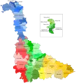 Kantone im Département Meurthe-et-Moselle
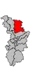 Lage des Kantons Nomeny im Arrondissement Nancy
Gemeinden
Der Kanton bestand aus 25 Gemeinden:
| Gemeinde | Einwohner Jahr | Fläche km² | Bevölkerungsdichte | Code INSEE | Postleitzahl |
|---|---|---|---|---|---|
| Abaucourt | 304 (2013) | 7,80 | 39 Einw./km² | 54001 | 54610 |
| Armaucourt | 217 (2013) | 3,72 | 58 Einw./km² | 54021 | 54760 |
| Arraye-et-Han | 343 (2013) | 10,34 | 33 Einw./km² | 54024 | 54760 |
| Belleau | 781 (2013) | 20,38 | 38 Einw./km² | 54059 | 54610 |
| Bey-sur-Seille | 155 (2013) | 5,53 | 28 Einw./km² | 54070 | 54760 |
| Bratte | 42 (2013) | 3,28 | 13 Einw./km² | 54095 | 54610 |
| Chenicourt | 229 (2013) | 3,75 | 61 Einw./km² | 54126 | 54610 |
| Clémery | 508 (2013) | 9,45 | 54 Einw./km² | 54131 | 54610 |
| Éply | 305 (2013) | 11,17 | 27 Einw./km² | 54179 | 54610 |
| Faulx | 1.312 (2013) | 17,20 | 76 Einw./km² | 54188 | 54760 |
| Jeandelaincourt | 802 (2013) | 4,47 | 179 Einw./km² | 54276 | 54114 |
| Lanfroicourt | 128 (2013) | 6,19 | 21 Einw./km² | 54301 | 54760 |
| Létricourt | 251 (2013) | 7,38 | 34 Einw./km² | 54313 | 54610 |
| Leyr | 973 (2013) | 10,74 | 91 Einw./km² | 54315 | 54760 |
| Mailly-sur-Seille | 253 (2013) | 6,40 | 40 Einw./km² | 54333 | 54610 |
| Malleloy | 957 (2013) | 4,06 | 236 Einw./km² | 54338 | 54670 |
| Moivrons | 471 (2013) | 6,00 | 79 Einw./km² | 54372 | 54760 |
| Montenoy | 410 (2013) | 3,98 | 103 Einw./km² | 54376 | 54760 |
| Nomeny | 1.185 (2013) | 17,79 | 67 Einw./km² | 54400 | 54610 |
| Phlin | 38 (2013) | 3,70 | 10 Einw./km² | 54424 | 54610 |
| Raucourt | 214 (2013) | 5,06 | 42 Einw./km² | 54444 | 54610 |
| Rouves | 107 (2013) | 3,69 | 29 Einw./km² | 54464 | 54610 |
| Sivry | 258 (2013) | 5,91 | 44 Einw./km² | 54508 | 54610 |
| Thézey-Saint-Martin | 204 (2013) | 7,95 | 26 Einw./km² | 54517 | 54610 |
| Villers-lès-Moivrons | 144 (2013) | 2,85 | 51 Einw./km² | 54577 | 54760 |
Bevölkerungsentwicklung
| 1962 | 1968 | 1975 | 1982 | 1990 | 1999 | 2006 | 2012 |
|---|---|---|---|---|---|---|---|
| 7.137 | 7.841 | 7.593 | 8.130 | 8.699 | 9.290 | 9.935 | 10.560 |
This article is issued from Wikipedia. The text is licensed under Creative Commons - Attribution - Sharealike. The authors of the article are listed here. Additional terms may apply for the media files, click on images to show image meta data.