Saint-Guyomard
| Saint-Guyomard Saent-Giomarr | ||
|---|---|---|
.svg.png.webp)
|
| |
| Staat | Frankreich | |
| Region | Bretagne | |
| Département (Nr.) | Morbihan (56) | |
| Arrondissement | Vannes | |
| Kanton | Moréac | |
| Gemeindeverband | De l’Oust à Brocéliande Communauté | |
| Koordinaten | 47° 47′ N, 2° 31′ W | |
| Höhe | 20–108 m | |
| Fläche | 19,80 km² | |
| Einwohner | 1.389 (1. Januar 2019) | |
| Bevölkerungsdichte | 70 Einw./km² | |
| Postleitzahl | 56460 | |
| INSEE-Code | 56219 | |
| Website | http://www.saint-guyomard.fr/ | |
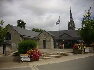 Rathaus von Saint-Guyomard und Kirche Saint-Maurice | ||

Saint-Guyomard (Gallo Saent-Giomarr, bretonisch Sant-Gwioñvarc’h) ist eine französische Gemeinde mit 1.389 Einwohnern (Stand 1. Januar 2019) im Département Morbihan in der Region Bretagne.
Geografie
Saint-Guyomard liegt rund 23 Kilometer nordöstlich von Vannes im Osten des Départements Morbihan. Nachbargemeinden sind Sérent im Norden, Bohal im Osten, Molac im Südosten, Le Cours im Süden sowie Trédion im Südwesten und Westen.
Die Allée couverte du Bignon liegt östlich von Saint-Guyomard und der Menhir Le Passoir mitten im Weiler Le Clos.
Bevölkerungsentwicklung
| 1793 | 1896 | 1962 | 1968 | 1975 | 1982 | 1990 | 1999 | 2006 | 2012 | ||
|---|---|---|---|---|---|---|---|---|---|---|---|
| 730 | 935 | 848 | 770 | 717 | 779 | 792 | 810 | 976 | 1198 | ||
| Quellen: Cassini und INSEE | |||||||||||
Baudenkmäler
Literatur
- Le Patrimoine des Communes du Morbihan. Flohic Editions, Band 2, Paris 1996, ISBN 2-84234-009-4, S. 577–579.
Weblinks
Commons: Saint-Guyomard – Sammlung von Bildern, Videos und Audiodateien
This article is issued from Wikipedia. The text is licensed under Creative Commons - Attribution - Sharealike. The authors of the article are listed here. Additional terms may apply for the media files, click on images to show image meta data.