Géraudot
Géraudot ist eine französische Gemeinde mit 337 Einwohnern (Stand 1. Januar 2019) im Département Aube in der Region Grand Est (vor 2016 Champagne-Ardenne). Sie gehört zum Kanton Brienne-le-Château (bis 2015 Piney) im Arrondissement Troyes.
| Géraudot | ||
|---|---|---|

|
| |
| Staat | Frankreich | |
| Region | Grand Est | |
| Département (Nr.) | Aube (10) | |
| Arrondissement | Troyes | |
| Kanton | Brienne-le-Château | |
| Gemeindeverband | Forêts, Lacs, Terres en Champagne | |
| Koordinaten | 48° 19′ N, 4° 19′ O | |
| Höhe | 114–152 m | |
| Fläche | 16,09 km² | |
| Einwohner | 337 (1. Januar 2019) | |
| Bevölkerungsdichte | 21 Einw./km² | |
| Postleitzahl | 10220 | |
| INSEE-Code | 10165 | |
| Website | http://www.geraudot.fr/ | |
 Rathaus (Mairie) von Géraudot | ||

Geographie
Géraudot liegt etwa 18 Kilometer östlich von Troyes am Lac d’Orient. Nachbargemeinden sind Rouilly-Sacey im Norden und Nordwesten, Piney im Norden und Osten, Mesnil-Saint-Père im Süden sowie Dosches im Süden und Westen.
Bevölkerungsentwicklung
| Jahr | 1962 | 1968 | 1975 | 1982 | 1990 | 1999 | 2006 | 2011 | 2016 |
|---|---|---|---|---|---|---|---|---|---|
| Einwohner | 264 | 246 | 239 | 255 | 274 | 291 | 288 | 304 | 337 |
| Quelle: Cassini und INSEE | |||||||||
Sehenswürdigkeiten
- Kirche Saint-Pierre-Saint-Paul aus dem 12. Jahrhundert, seit 2015 Monument historique
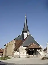
Kirche Saint-Pierre-Saint-Paul
This article is issued from Wikipedia. The text is licensed under Creative Commons - Attribution - Sharealike. The authors of the article are listed here. Additional terms may apply for the media files, click on images to show image meta data.