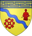
Crésantignes
Crésantignes ist eine französische Gemeinde mit 316 Einwohnern (Stand 1. Januar 2019) im Département Aube in der Region Grand Est (vor 2016 Champagne-Ardenne). Sie gehört zum Arrondissement Troyes und zum Kanton Les Riceys (bis 2015 Bouilly). Die Einwohner werden Créteignats genannt.
| Crésantignes | ||
|---|---|---|
|
| |
| Staat | Frankreich | |
| Region | Grand Est | |
| Département (Nr.) | Aube (10) | |
| Arrondissement | Troyes | |
| Kanton | Les Riceys | |
| Gemeindeverband | Troyes Champagne Métropole | |
| Koordinaten | 48° 9′ N, 4° 1′ O | |
| Höhe | 174–294 m | |
| Fläche | 2,09 km² | |
| Einwohner | 316 (1. Januar 2019) | |
| Bevölkerungsdichte | 151 Einw./km² | |
| Postleitzahl | 10320 | |
| INSEE-Code | 10116 | |

Geographie
Crésantignes liegt etwa 17 Kilometer südsüdwestlich von Troyes. Umgeben wird Crésantignes von den Nachbargemeinden Machy im Norden und Osten, Jeugny im Südosten, Fays-la-Chapelle im Süden sowie Saint-Phal im Süden und Westen.
Bevölkerungsentwicklung
| Jahr | 1962 | 1968 | 1975 | 1982 | 1990 | 1999 | 2006 | 2011 | 2016 | ||||||||
| Einwohner | 248 | 208 | 202 | 256 | 277 | 269 | 276 | 297 | 312 | ||||||||
| Quellen: Cassini und INSEE | |||||||||||||||||
Sehenswürdigkeiten
- Kirche Saint-Sébastien aus dem 16. Jahrhundert
- Museum Le Passé Simple
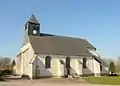 Kirche Saint-Sébastien
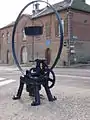 Museum Le Passé Simple
This article is issued from Wikipedia. The text is licensed under Creative Commons - Attribution - Sharealike. The authors of the article are listed here. Additional terms may apply for the media files, click on images to show image meta data.