Upaix
Upaix ist eine französische Gemeinde im Département Hautes-Alpes in der Region Provence-Alpes-Côte d’Azur. Sie gehört zum Kanton Laragne-Montéglin im Arrondissement Gap.
| Upaix | ||
|---|---|---|
|
| |
| Staat | Frankreich | |
| Region | Provence-Alpes-Côte d’Azur | |
| Département (Nr.) | Hautes-Alpes (05) | |
| Arrondissement | Gap | |
| Kanton | Laragne-Montéglin | |
| Gemeindeverband | Sisteronais-Buëch | |
| Koordinaten | 44° 19′ N, 5° 53′ O | |
| Höhe | 494–757 m | |
| Fläche | 23,30 km² | |
| Einwohner | 457 (1. Januar 2019) | |
| Bevölkerungsdichte | 20 Einw./km² | |
| Postleitzahl | 05300 | |
| INSEE-Code | 05173 | |
 Upaix | ||

Geographie
Die Gemeinde Upaix liegt auf 720 m über dem Meer an der Durance und dem parallel verlaufenden Canal EDF. Sie grenzt im Norden an Ventavon, im Osten an Thèze und Sigoyer, beide im Département Alpes-de-Haute-Provence, im Süden an Le Poët und Mison, die letztgenannte Gemeinde im Département Alpes-de-Haute-Provence sowie im Westen an Laragne-Montéglin und Lazer.
Geschichte
Von Upaix sind frühere Ortsnamen bekannt: Upaga (739), Upsal (1241), Castrum de Upaysio (1262).
Bevölkerungsentwicklung
| Jahr | 1962 | 1968 | 1975 | 1982 | 1990 | 1999 | 2006 | 2012 | 2018 |
|---|---|---|---|---|---|---|---|---|---|
| Einwohner | 324 | 328 | 331 | 284 | 359 | 376 | 400 | 431 | 454 |
Sehenswürdigkeiten
- Altes Schloss, Monument historique
- Kirche Nativité-de-Notre-Dame-d’Upaix (Mariä Geburt), Monument historique
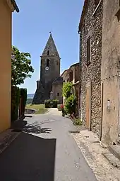
Kirche Mariä Geburt
This article is issued from Wikipedia. The text is licensed under Creative Commons - Attribution - Sharealike. The authors of the article are listed here. Additional terms may apply for the media files, click on images to show image meta data.