Manteyer
Manteyer ist eine französische Gemeinde im Département Hautes-Alpes in der Region Provence-Alpes-Côte d’Azur. Sie gehört zum Kanton Veynes im Arrondissement Gap.
| Manteyer | ||
|---|---|---|

|
| |
| Staat | Frankreich | |
| Region | Provence-Alpes-Côte d’Azur | |
| Département (Nr.) | Hautes-Alpes (05) | |
| Arrondissement | Gap | |
| Kanton | Veynes | |
| Gemeindeverband | Buëch-Dévoluy | |
| Koordinaten | 44° 32′ N, 5° 58′ O | |
| Höhe | 890–1974 m | |
| Fläche | 25,30 km² | |
| Einwohner | 427 (1. Januar 2019) | |
| Bevölkerungsdichte | 17 Einw./km² | |
| Postleitzahl | 05400 | |
| INSEE-Code | 05075 | |
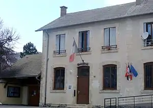 Mairie Manteyer | ||

Geografie
Der Gebirgsfluss Petit Buëch fließt im Nordwesten der Gemeindegrenze entlang. Die Nachbargemeinden von Manteyer sind La Roche-des-Arnauds im Norden, La Freissinouse im Osten, Pelleautier im Südosten, Châteauneuf-d’Oze im Südwesten und Montmaur im Westen.
Bevölkerungsentwicklung
| Jahr | 1962 | 1968 | 1975 | 1982 | 1990 | 1999 | 2008 | 2012 |
|---|---|---|---|---|---|---|---|---|
| Einwohner | 207 | 200 | 178 | 211 | 222 | 305 | 414 | 423 |
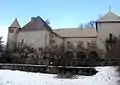 Schloss von Manteyer
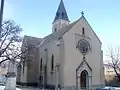 Kirche Saint-Roch
This article is issued from Wikipedia. The text is licensed under Creative Commons - Attribution - Sharealike. The authors of the article are listed here. Additional terms may apply for the media files, click on images to show image meta data.