Champoléon
Champoléon ist eine französische Gemeinde im Département Hautes-Alpes in der Region Provence-Alpes-Côte d’Azur. Sie gehört zum Kanton Saint-Bonnet-en-Champsaur im Arrondissement Gap. Die Bewohner nennen sich Champoléards.
| Champoléon | ||
|---|---|---|
.svg.png.webp)
|
| |
| Staat | Frankreich | |
| Region | Provence-Alpes-Côte d’Azur | |
| Département (Nr.) | Hautes-Alpes (05) | |
| Arrondissement | Gap | |
| Kanton | Saint-Bonnet-en-Champsaur | |
| Gemeindeverband | Champsaur-Valgaudemar | |
| Koordinaten | 44° 43′ N, 6° 16′ O | |
| Höhe | 1173–3439 m | |
| Fläche | 101,89 km² | |
| Einwohner | 136 (1. Januar 2019) | |
| Bevölkerungsdichte | 1 Einw./km² | |
| Postleitzahl | 05260 | |
| INSEE-Code | 05032 | |
 typisches Haus in Champoléon | ||

Die Gemeinde grenzt im Nordwesten und im Norden an La Chapelle-en-Valgaudémar, im Nordosten an Vallouise-Pelvoux, im Osten an L’Argentière-la-Bessée und Freissinières, im Südosten an Orcières, im Süden an Saint-Jean-Saint-Nicolas, im Südwesten an Saint-Michel-de-Chaillol und im Westen an La Motte-en-Champsaur.
Bevölkerungsentwicklung
| Jahr | 1962 | 1968 | 1975 | 1982 | 1990 | 1999 | 2008 | 2012 | 2018 |
|---|---|---|---|---|---|---|---|---|---|
| Einwohner | 193 | 135 | 110 | 116 | 102 | 113 | 125 | 136 | 136 |
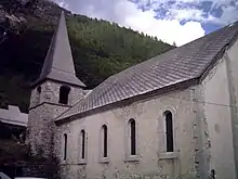
Kirche Saint-Vincent im Ortsteil Les Borels
This article is issued from Wikipedia. The text is licensed under Creative Commons - Attribution - Sharealike. The authors of the article are listed here. Additional terms may apply for the media files, click on images to show image meta data.