Aspremont (Hautes-Alpes)
Aspremont ist eine französische Gemeinde mit 369 Einwohnern (Stand 1. Januar 2019) im Département Hautes-Alpes in der Region Provence-Alpes-Côte d’Azur.
| Aspremont | ||
|---|---|---|
.svg.png.webp)
|
| |
| Staat | Frankreich | |
| Region | Provence-Alpes-Côte d’Azur | |
| Département (Nr.) | Hautes-Alpes (05) | |
| Arrondissement | Gap | |
| Kanton | Serres | |
| Gemeindeverband | Buëch-Dévoluy | |
| Koordinaten | 44° 30′ N, 5° 44′ O | |
| Höhe | 696–1378 m | |
| Fläche | 18,65 km² | |
| Einwohner | 369 (1. Januar 2019) | |
| Bevölkerungsdichte | 20 Einw./km² | |
| Postleitzahl | 05140 | |
| INSEE-Code | 05008 | |
| Website | www.aspremont05.fr | |
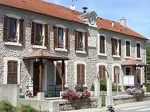
 Mairie (Rathaus) | ||
Geografie
Die Gemeinde liegt am Nordrand des Départements Hautes-Alpes in rund fünf Kilometern Entfernung zum Département Drôme. Aspremont liegt 40 Kilometer von Gap entfernt. Das Gemeindegebiet wird vom Fluss Buëch durchquert, in den hier von rechts die Chauranne einmündet.
Bevölkerungsentwicklung
| Jahr | 1962 | 1968 | 1975 | 1982 | 1990 | 1999 | 2007 | 2018 |
| Einwohner | 171 | 191 | 182 | 196 | 216 | 238 | 303 | 363 |
Sehenswürdigkeiten
- Schlossruine
- Kirche Saint-Pierre-aux-Liens aus dem 17. Jahrhundert

Kirche Saint-Pierre-aux-Liens
Verkehr
Durch Aspremont führt die D1075, die nach Norden hin auf die A51 nach Grenoble führt. In Richtung Süden führt die Straße ebenfalls auf die A51, in Richtung Aix-en-Provence.
This article is issued from Wikipedia. The text is licensed under Creative Commons - Attribution - Sharealike. The authors of the article are listed here. Additional terms may apply for the media files, click on images to show image meta data.
