Éourres
Éourres ist eine französische Gemeinde im Département Hautes-Alpes in der Region Provence-Alpes-Côte d’Azur. Sie gehört zum Kanton Laragne-Montéglin im Arrondissement Gap. Éourres ist die südlichste Gemeinde des Départements Hautes-Alpes. Sie grenzt im Norden an Salérans, Barret-sur-Méouge und Saint-Pierre-Avez, im Osten an Ribiers, im Süden an Noyers-sur-Jabron, Saint-Vincent-sur-Jabron und Curel sowie im Westen an Lachau.
| Éourres | ||
|---|---|---|
| ||
| Staat | Frankreich | |
| Region | Provence-Alpes-Côte d’Azur | |
| Département (Nr.) | Hautes-Alpes (05) | |
| Arrondissement | Gap | |
| Kanton | Laragne-Montéglin | |
| Gemeindeverband | Sisteronais-Buëch | |
| Koordinaten | 44° 13′ N, 5° 42′ O | |
| Höhe | 759–1613 m | |
| Fläche | 26,70 km² | |
| Einwohner | 125 (1. Januar 2019) | |
| Bevölkerungsdichte | 5 Einw./km² | |
| Postleitzahl | 05300 | |
| INSEE-Code | 05047 | |

Bevölkerungsentwicklung
| Jahr | 1962 | 1968 | 1975 | 1982 | 1990 | 1999 | 2008 | 2014 |
|---|---|---|---|---|---|---|---|---|
| Einwohner | 39 | 28 | 28 | 22 | 73 | 85 | 143 | 131 |
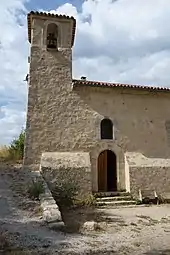
Kirche Saint-Étienne
This article is issued from Wikipedia. The text is licensed under Creative Commons - Attribution - Sharealike. The authors of the article are listed here. Additional terms may apply for the media files, click on images to show image meta data.