Villar-Loubière
Villar-Loubière ist eine französische Gemeinde im Département Hautes-Alpes in der Region Provence-Alpes-Côte d’Azur. Sie gehört zum Kanton Saint-Bonnet-en-Champsaur im Arrondissement Gap.
| Villar-Loubière | ||
|---|---|---|
| ||
| Staat | Frankreich | |
| Region | Provence-Alpes-Côte d’Azur | |
| Département (Nr.) | Hautes-Alpes (05) | |
| Arrondissement | Gap | |
| Kanton | Saint-Bonnet-en-Champsaur | |
| Gemeindeverband | Champsaur-Valgaudemar | |
| Koordinaten | 44° 50′ N, 6° 9′ O | |
| Höhe | 975–3098 m | |
| Fläche | 21,97 km² | |
| Einwohner | 42 (1. Januar 2019) | |
| Bevölkerungsdichte | 2 Einw./km² | |
| Postleitzahl | 05800 | |
| INSEE-Code | 05182 | |
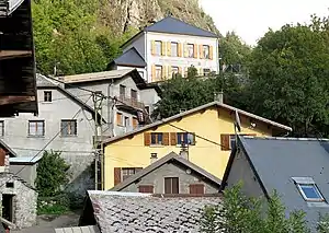 Blick auf Villar-Loubière | ||

Geographie
Die Gemeinde liegt in den französischen Seealpen an der Landesgrenze zu Italien. Die französischen Nachbargemeinden sind Saint-Maurice-en-Valgodemard und La Chapelle-en-Valgaudémar.
Bevölkerungsentwicklung
| Jahr | 1962 | 1968 | 1975 | 1982 | 1990 | 1999 | 2008 | 2012 |
|---|---|---|---|---|---|---|---|---|
| Einwohner | 90 | 95 | 78 | 74 | 59 | 62 | 49 | 45 |
Sehenswürdigkeiten
- Wassermühle, als Monument historique eingestuft
This article is issued from Wikipedia. The text is licensed under Creative Commons - Attribution - Sharealike. The authors of the article are listed here. Additional terms may apply for the media files, click on images to show image meta data.