Sigoyer (Alpes-de-Haute-Provence)
Sigoyer ist eine französische Gemeinde mit 103 Einwohnern (Stand 1. Januar 2019) im Département Alpes-de-Haute-Provence in der Region Provence-Alpes-Côte d’Azur. Sie gehört zum Arrondissement Forcalquier und zum Kanton Seyne.
| Sigoyer | ||
|---|---|---|
|
| |
| Staat | Frankreich | |
| Region | Provence-Alpes-Côte d’Azur | |
| Département (Nr.) | Alpes-de-Haute-Provence (04) | |
| Arrondissement | Forcalquier | |
| Kanton | Seyne | |
| Gemeindeverband | Sisteronais-Buëch | |
| Koordinaten | 44° 19′ N, 5° 58′ O | |
| Höhe | 482–945 m | |
| Fläche | 15,38 km² | |
| Einwohner | 103 (1. Januar 2019) | |
| Bevölkerungsdichte | 7 Einw./km² | |
| Postleitzahl | 04200 | |
| INSEE-Code | 04207 | |
 Sigoyer | ||

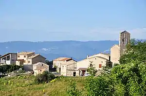
Geographie
Der Dorfkern befindet sich auf 805 m. 754 Hektar der Gemeindegemarkung sind bewaldet. Die Gemeinde grenzt im Norden an Melve, im Osten an La Motte-du-Caire, im Süden an Vaumeilh, im Südwesten an Le Poët und Upaix sowie im Westen an Thèze.
Bevölkerungsentwicklung
| Jahr | 1962 | 1968 | 1975 | 1982 | 1990 | 1999 | 2008 | 2012 |
|---|---|---|---|---|---|---|---|---|
| Einwohner | 71 | 70 | 72 | 83 | 88 | 75 | 86 | 101 |
This article is issued from Wikipedia. The text is licensed under Creative Commons - Attribution - Sharealike. The authors of the article are listed here. Additional terms may apply for the media files, click on images to show image meta data.