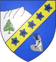
Laye (Hautes-Alpes)
Laye ist eine französische Gemeinde im Département Hautes-Alpes in der Region Provence-Alpes-Côte d’Azur. Sie gehört zum Arrondissement Gap und zum Kanton Saint-Bonnet-en-Champsaur. Die Gemeinde grenzt im Norden an La Fare-en-Champsaur, im Nordosten an Saint-Bonnet-en-Champsaur, im Osten an Saint-Laurent-du-Cros sowie im Süden und im Westen an Gap.
| Laye | ||
|---|---|---|
|
| |
| Staat | Frankreich | |
| Region | Provence-Alpes-Côte d’Azur | |
| Département (Nr.) | Hautes-Alpes (05) | |
| Arrondissement | Gap | |
| Kanton | Saint-Bonnet-en-Champsaur | |
| Gemeindeverband | Champsaur-Valgaudemar | |
| Koordinaten | 44° 40′ N, 6° 5′ O | |
| Höhe | 976–2158 m | |
| Fläche | 10,64 km² | |
| Einwohner | 243 (1. Januar 2019) | |
| Bevölkerungsdichte | 23 Einw./km² | |
| Postleitzahl | 05500 | |
| INSEE-Code | 05072 | |
 Laye | ||

Bevölkerungsentwicklung
| Jahr | 1962 | 1968 | 1975 | 1982 | 1990 | 1999 | 2006 | 2012 |
|---|---|---|---|---|---|---|---|---|
| Einwohner | 185 | 155 | 137 | 163 | 192 | 212 | 217 | 245 |
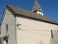 Kirche Saint-Pierre
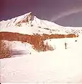 Wintersportgebiet
This article is issued from Wikipedia. The text is licensed under Creative Commons - Attribution - Sharealike. The authors of the article are listed here. Additional terms may apply for the media files, click on images to show image meta data.