Jarjayes
Jarjayes ist eine Gemeinde in Frankreich. Sie gehört zur Region Provence-Alpes-Côte d’Azur, zum Département Hautes-Alpes, zum Arrondissement Gap und zum Kanton Tallard.
| Jarjayes | ||
|---|---|---|

|
| |
| Staat | Frankreich | |
| Region | Provence-Alpes-Côte d’Azur | |
| Département (Nr.) | Hautes-Alpes (05) | |
| Arrondissement | Gap | |
| Kanton | Tallard | |
| Gemeindeverband | Gap-Tallard-Durance | |
| Koordinaten | 44° 30′ N, 6° 7′ O | |
| Höhe | 586–1310 m | |
| Fläche | 22,89 km² | |
| Einwohner | 460 (1. Januar 2019) | |
| Bevölkerungsdichte | 20 Einw./km² | |
| Postleitzahl | 05130 | |
| INSEE-Code | 05068 | |
 Jarjayes | ||

Geografie
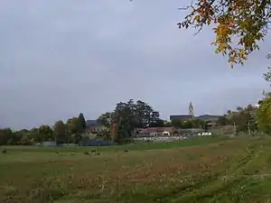
Der Dorfkern befindet sich auf 1000 m in den Seealpen. Die Gemeinde grenzt im Norden an Rambaud, im Nordosten an Saint-Étienne-le-Laus, im Osten an Valserres, im Süden an Venterol, im Südwesten an Lettret und im Nordwesten an Gap. Im Süden von Jarjayes fließt die Avance in die Durance.
Bevölkerungsentwicklung
| Jahr | 1962 | 1968 | 1975 | 1982 | 1990 | 1999 | 2008 | 2012 |
|---|---|---|---|---|---|---|---|---|
| Einwohner | 210 | 196 | 203 | 254 | 312 | 379 | 418 | 418 |
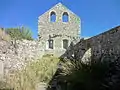 Überreste der vormaligen Kirche Saint-Thomas-Saint-Restitut
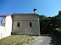 Kapelle Saint-Pierre
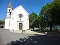 heutige Kirche Saint-Thomas-Saint-Restitut
This article is issued from Wikipedia. The text is licensed under Creative Commons - Attribution - Sharealike. The authors of the article are listed here. Additional terms may apply for the media files, click on images to show image meta data.