Lardier-et-Valença
Lardier-et-Valença ist eine französische Gemeinde im Département Hautes-Alpes in der Region Provence-Alpes-Côte d’Azur. Sie gehört zum Arrondissement Gap und zum Kanton Tallard.
| Lardier-et-Valença | ||
|---|---|---|

|
| |
| Staat | Frankreich | |
| Region | Provence-Alpes-Côte d’Azur | |
| Département (Nr.) | Hautes-Alpes (05) | |
| Arrondissement | Gap | |
| Kanton | Tallard | |
| Gemeindeverband | Gap-Tallard-Durance | |
| Koordinaten | 44° 26′ N, 5° 59′ O | |
| Höhe | 548–1482 m | |
| Fläche | 14,77 km² | |
| Einwohner | 338 (1. Januar 2019) | |
| Bevölkerungsdichte | 23 Einw./km² | |
| Postleitzahl | 05110 | |
| INSEE-Code | 05071 | |
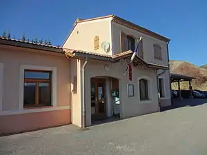 Mairie Lardier-et-Valença | ||

Geografie
Die Gemeindegemarkung wird im Süden vom Fluss Durance tangiert. Nördlich des Fließgewässers verlaufen die Autoroute A51 und der EDF-Kanal Canal de Sisteron. Die angrenzenden Gemeinden sind Sigoyer im Norden, Fouillouse im Nordosten, La Saulce im Südosten, Curbans im Süden und Vitrolles im Westen.
Bevölkerungsentwicklung
| Jahr | 1962 | 1968 | 1975 | 1982 | 1990 | 1999 | 2006 | 2012 |
|---|---|---|---|---|---|---|---|---|
| Einwohner | 147 | 157 | 134 | 145 | 176 | 198 | 253 | 312 |
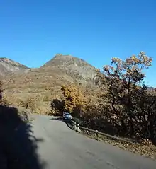
Sommet de Sainte-Croix, ein 1053 m hoher Berg
This article is issued from Wikipedia. The text is licensed under Creative Commons - Attribution - Sharealike. The authors of the article are listed here. Additional terms may apply for the media files, click on images to show image meta data.