La Bâtie-Montsaléon
La Bâtie-Montsaléon ist eine französische Gemeinde im Département Hautes-Alpes in der Region Provence-Alpes-Côte d’Azur. Sie gehört zum Kanton Serres im Arrondissement Gap. Die Gemeinde grenzt im Nordosten an Chabestan, im Südosten an Savournon, im Südwesten an Serres, im Westen an Sigottier und im Nordwesten an Aspremont. La Bâtie-Montsaléon wird vom Fluss Petit Buëch durchquert.
| La Bâtie-Montsaléon | ||
|---|---|---|

|
| |
| Staat | Frankreich | |
| Region | Provence-Alpes-Côte d’Azur | |
| Département (Nr.) | Hautes-Alpes (05) | |
| Arrondissement | Gap | |
| Kanton | Serres | |
| Gemeindeverband | Sisteronais-Buëch | |
| Koordinaten | 44° 27′ N, 5° 45′ O | |
| Höhe | 671–1431 m | |
| Fläche | 15,05 km² | |
| Einwohner | 256 (1. Januar 2019) | |
| Bevölkerungsdichte | 17 Einw./km² | |
| Postleitzahl | 05700 | |
| INSEE-Code | 05016 | |
 Mairie La Bâtie-Monzsaléon | ||

Bevölkerungsentwicklung
| Jahr | 1962 | 1968 | 1975 | 1982 | 1990 | 1999 | 2008 | 2012 |
|---|---|---|---|---|---|---|---|---|
| Einwohner | 154 | 134 | 132 | 134 | 137 | 136 | 200 | 220 |
Sehenswürdigkeiten
- Himmelfahrts-Kirche (Église de l’Assomption), Monument historique
- Château de La Bâtie-Montsaléon
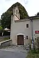 Himmelfahrts-Kirche
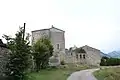 Château de La Bâtie-Montsaléon
This article is issued from Wikipedia. The text is licensed under Creative Commons - Attribution - Sharealike. The authors of the article are listed here. Additional terms may apply for the media files, click on images to show image meta data.