Chanousse
Chanousse ist eine französische Gemeinde im Département Hautes-Alpes in der Region Provence-Alpes-Côte d’Azur. Sie gehört zum Kanton Serres im Arrondissement Gap.
| Chanousse | ||
|---|---|---|
| ||
| Staat | Frankreich | |
| Region | Provence-Alpes-Côte d’Azur | |
| Département (Nr.) | Hautes-Alpes (05) | |
| Arrondissement | Gap | |
| Kanton | Serres | |
| Gemeindeverband | Sisteronais-Buëch | |
| Koordinaten | 44° 21′ N, 5° 39′ O | |
| Höhe | 695–1520 m | |
| Fläche | 20,54 km² | |
| Einwohner | 40 (1. Januar 2019) | |
| Bevölkerungsdichte | 2 Einw./km² | |
| Postleitzahl | 05700 | |
| INSEE-Code | 05033 | |

Geografie
Zur Gemeinde gehören neben der Hauptsiedlung auch die Weiler Les Chabanas, Les Courtilles, Le Couvent, Les Granges, La Combe, La Baume und Le Moulin. Chanousse liegt am Fluss Blaisance und grenzt im Norden an Montclus, im Nordosten an Méreuil, im Osten an Trescléoux, im Südosten an Orpierre, im Süden an Étoile-Saint-Cyrice und im Westen an Montjay.
Bevölkerungsentwicklung
| Jahr | 1962 | 1968 | 1975 | 1982 | 1990 | 1999 | 2006 | 2013 |
|---|---|---|---|---|---|---|---|---|
| Einwohner | 44 | 30 | 22 | 29 | 30 | 34 | 44 | 54 |
Sehenswürdigkeiten
- Kapelle im Weiler Les Courtilles, erbaut um 1650
- Kirche Saint-Sébastien, erbaut um 1850
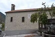
Kirche Saint-Sébastien
This article is issued from Wikipedia. The text is licensed under Creative Commons - Attribution - Sharealike. The authors of the article are listed here. Additional terms may apply for the media files, click on images to show image meta data.