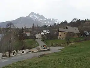
Puy-Sanières
Puy-Sanières ist eine französische Gemeinde im Département Hautes-Alpes in der Region Provence-Alpes-Côte d’Azur. Sie gehört zum Kanton Chorges im Arrondissement Gap.
| Puy-Sanières | ||
|---|---|---|

|
| |
| Staat | Frankreich | |
| Region | Provence-Alpes-Côte d’Azur | |
| Département (Nr.) | Hautes-Alpes (05) | |
| Arrondissement | Gap | |
| Kanton | Chorges | |
| Gemeindeverband | Serre-Ponçon | |
| Koordinaten | 44° 34′ N, 6° 26′ O | |
| Höhe | 780–2524 m | |
| Fläche | 11,54 km² | |
| Einwohner | 273 (1. Januar 2019) | |
| Bevölkerungsdichte | 24 Einw./km² | |
| Postleitzahl | 05200 | |
| INSEE-Code | 05111 | |
 Puy-Sanières | ||

Geografie
Puy-Sanières liegt am Nordufer des Lac de Serre-Ponçon sowie nahe der Südflanke des 2552 m hohen Mont Guillaume im Bereich des Bergmassivs Massif des Écrins. Die Gemeinde grenzt im Nordwesten Puy-Saint-Eusèbe, im Nordosten an Embrun, im Süden an Crots und im Südwesten an Savines-le-Lac.
Geschichte
Aus dem 13. Jahrhundert ist der Ortsname „Podium Sagnerarium“ überliefert.
Bevölkerungsentwicklung
| Jahr | 1962 | 1968 | 1975 | 1982 | 1990 | 1999 | 2006 | 2012 |
|---|---|---|---|---|---|---|---|---|
| Einwohner | 114 | 78 | 66 | 31 | 106 | 155 | 204 | 231 |
Weblinks
Commons: Puy-Sanières – Sammlung von Bildern, Videos und Audiodateien
- Information über den Bahnhof von Puy-Sanières (französisch)
This article is issued from Wikipedia. The text is licensed under Creative Commons - Attribution - Sharealike. The authors of the article are listed here. Additional terms may apply for the media files, click on images to show image meta data.