Pennington County (South Dakota)
Pennington County[1] ist ein County im Bundesstaat South Dakota der Vereinigten Staaten. Im Jahre 2010 betrug die Bevölkerung 100.948 Einwohner. Der Verwaltungssitz (County Seat) ist Rapid City, die zweitgrößte Stadt in South Dakota.
.jpg.webp) Pennington County Courthouse | |
| Verwaltung | |
|---|---|
| US-Bundesstaat: | South Dakota |
| Verwaltungssitz: | Rapid City |
| Adresse des Verwaltungssitzes: |
Pennington County Courthouse 315 Saint Joseph Street Rapid City, SD 57701101 E |
| Gründung: | 1875 |
| Demographie | |
| Einwohner: | 100.948 (2010) |
| Bevölkerungsdichte: | 14,04 Einwohner/km2 |
| Geographie | |
| Fläche gesamt: | 7211 km² |
| Wasserfläche: | 21 km² |
| Karte | |
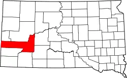 Karte von Pennington County innerhalb von South Dakota | |
| Website: www.co.pennington.sd.us | |
Geschichte
Pennington County wurde am 11. Januar 1875 gegründet und am 19. April 1877 abschließend organisiert. Es ist nach John L. Pennington, dem damaligen Gouverneur des Dakota-Territoriums benannt.[2]
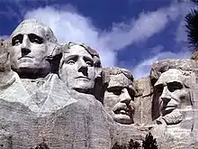
Zwei Orte im County sind von herausragender historischer Bedeutung: die Minuteman Missile National Historic Site und das Mount Rushmore National Memorial.[3] 59 Bauwerke und Stätten des Countys sind im National Register of Historic Places (NRHP) eingetragen (Stand 29. Juli 2018).[4]
Geographie
Die Fläche des Countys beträgt 7211 Quadratkilometer. Davon sind 21 Quadratkilometer (0,29 Prozent) Wasserfläche. Das County grenzt im Uhrzeigersinn an folgende andere Countys: Meade County, Haakon County, Jackson County, Oglala Lakota County, Custer County, Weston County in Wyoming und Lawrence County.
Im Gebiet des Countys befindet sich der Mount Rushmore. In diesen Berg wurden Abbilder der Köpfe von vier US-Präsidenten gehauen. Auch der Harney Peak, der höchste Berg Süddakotas, befindet sich in Pennington County.
Bevölkerungsentwicklung
| Bevölkerungsentwicklung | |||
|---|---|---|---|
| Census | Einwohner | ± in % | |
| 1900 | 5610 | — | |
| 1910 | 12.453 | 122 % | |
| 1920 | 12.720 | 2,1 % | |
| 1930 | 20.079 | 57,9 % | |
| 1940 | 23.799 | 18,5 % | |
| 1950 | 34.053 | 43,1 % | |
| 1960 | 58.195 | 70,9 % | |
| 1970 | 59.349 | 2 % | |
| 1980 | 70.361 | 18,6 % | |
| 1990 | 81.343 | 15,6 % | |
| 2000 | 88.565 | 8,9 % | |
| 2010 | 100.948 | 14 % | |
| 1900–1990[5]
2000[6] | |||
Townships
Das County ist in 20 Townships eingeteilt: Ash, Castle Butte, Cedar Butte, Conata, Crooked Creed, Fairview, Flat Butte, Huron, Imlay, Lake Creek, Lake Flat, Lake Hill, Owanka, Peno, Quinn, Rainy Creek/Cheyenne, Scenic, Shyne, Sunnyside und Wasta; sowie sieben unorganisierte Territorien: Central Pennington, Dalzell Canyon, East Central Pennington, Mount Rushmore, Northeast Pennington, Rapid City East und West Pennington.
Weblinks
Einzelnachweise
- Pennington County im Geographic Names Information System des United States Geological Survey. Abgerufen am 22. Februar 2011
- Charles Curry Aiken, Joseph Nathan Kane: The American Counties: Origins of County Names, Dates of Creation, Area, and Population Data, 1950–2010. 6. Auflage. Scarecrow Press, Lanham 2013, ISBN 978-0-8108-8762-6, S. 238.
- Listing of National Historic Landmarks by State: South Dakota. National Park Service, abgerufen am 28. Juli 2018.
- Suchmaske Datenbank im National Register Information System. National Park Service, abgerufen am 29. Juli 2018.
- Auszug aus Census.gov. Abgerufen am 28. Februar 2011
- Auszug aus factfinder.census.gov Abgerufen am 28. Februar 2011
Liste der Countys in South Dakota
Aurora |
Beadle |
Bennett |
Bon Homme |
Brookings |
Brown |
Brule |
Buffalo |
Butte |
Campbell |
Charles Mix |
Clark |
Clay |
Codington |
Corson |
Custer |
Davison |
Day |
Deuel |
Dewey |
Douglas |
Edmunds |
Fall River |
Faulk |
Grant |
Gregory |
Haakon |
Hamlin |
Hand |
Hanson |
Harding |
Hughes |
Hutchinson |
Hyde |
Jackson |
Jerauld |
Jones |
Kingsbury |
Lake |
Lawrence |
Lincoln |
Lyman |
Marshall |
McCook |
McPherson |
Meade |
Mellette |
Miner |
Minnehaha |
Moody |
Oglala Lakota |
Pennington |
Perkins |
Potter |
Roberts |
Sanborn |
Spink |
Stanley |
Sully |
Todd |
Tripp |
Turner |
Union |
Walworth |
Yankton |
Ziebach