Meade County (South Dakota)
Meade County[1] ist ein County im Bundesstaat South Dakota der Vereinigten Staaten. Bei der Volkszählung im Jahr 2000 hatte Meade County 24.253 Einwohner.
| Verwaltung | |
|---|---|
| US-Bundesstaat: | South Dakota |
| Verwaltungssitz: | Sturgis |
| Gründung: | 1889 |
| Demographie | |
| Einwohner: | 25.434 (2010) |
| Bevölkerungsdichte: | 2,83 Einwohner/km2 |
| Geographie | |
| Fläche gesamt: | 9020 km² |
| Wasserfläche: | 31 km² |
| Karte | |
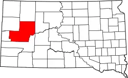 Karte von Meade County innerhalb von South Dakota | |
| Website: www.meadecounty.org | |
Geschichte
Es wurde am 7. Februar 1889 gegründet und nach Fort Meade benannt.[2] Das Fort Meade diente im Jahre 1878 als Garnison für die Militärpost und war nach George Gordon Meade benannt, einem General der Nordstaaten im Amerikanischen Bürgerkrieg und Kommandeur der Unionsarmee in der Schlacht von Gettysburg und anschließendem Kommandeur der Army of the Potomac bis Kriegsende. Der Verwaltungssitz (County Seat) ist Sturgis.
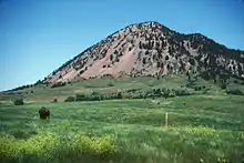
Ein Ort im County hat den Status einer National Historic Landmark, der Berg Bear Butte.[3] 27 Bauwerke und Stätten des Countys sind im National Register of Historic Places (NRHP) eingetragen (Stand 6. August 2018).[4]
Geographie
Meade County hat eine Fläche von 9020 Quadratkilometern, davon sind 8989 km² Land und 31 km² (0,34 %) Wasserfläche, damit ist der Bezirk der größte in Süddakota und ist etwa halb so groß wie Rheinland-Pfalz, hat aber bei knapp 25.000 Einwohnern nur eine Bevölkerungsdichte von 2,7 Einwohnern pro Quadratkilometer. Es grenzt im Uhrzeigersinn an die Countys: Perkins County, Ziebach County, Pennington County, Lawrence County und Butte County.
Bevölkerungsentwicklung
| Bevölkerungsentwicklung | |||
|---|---|---|---|
| Census | Einwohner | ± in % | |
| 1900 | 4907 | — | |
| 1910 | 12.640 | 157,6 % | |
| 1920 | 9367 | −25,9 % | |
| 1930 | 11.482 | 22,6 % | |
| 1940 | 9735 | −15,2 % | |
| 1950 | 11.516 | 18,3 % | |
| 1960 | 12.044 | 4,6 % | |
| 1970 | 16.618 | 38 % | |
| 1980 | 20.717 | 24,7 % | |
| 1990 | 21.878 | 5,6 % | |
| 2000 | 24.253 | 10,9 % | |
| 2010 | 25.434 | 4,9 % | |
| 1900–1990[5]
2000[6] | |||
Altersstruktur
- unter 18 = 28,4 Prozent
- 18–24 = 10,6 Prozent
- 25–44 = 29,6 Prozent
- 45–64 = 21,0 Prozent
- über 65 = 10,4 0 %
Städte und Gemeinden
Städte (cities)
Sonstige
- Blachhawk – ein zu Statistikzwecken definiertes Siedlungsgebiet (census-designated place)
- Ellsworth AFB (Militärflugplatz)
Townships
Das County ist in sechs Townships eingeteilt: Dakota, Eagle, Howard, Lakeside, Smithville und Upper Red Owl; sowie drei unorganisierte Territorien: Belle Fourche-Cheyenne Valleys, North Meade und Southwest Meade.
Weblinks
Einzelnachweise
- Meade County im Geographic Names Information System des United States Geological Survey. Abgerufen am 22. Februar 2011
- Charles Curry Aiken, Joseph Nathan Kane: The American Counties: Origins of County Names, Dates of Creation, Area, and Population Data, 1950–2010. 6. Auflage. Scarecrow Press, Lanham 2013, ISBN 978-0-8108-8762-6, S. 202.
- Listing of National Historic Landmarks by State: South Dakota. National Park Service, abgerufen am 6. August 2018.
- Suchmaske Datenbank im National Register Information System. National Park Service, abgerufen am 6. August 2018.
- Auszug aus Census.gov. Abgerufen am 28. Februar 2011
- Auszug aus factfinder.census.gov Abgerufen am 28. Februar 2011
Liste der Countys in South Dakota
Aurora |
Beadle |
Bennett |
Bon Homme |
Brookings |
Brown |
Brule |
Buffalo |
Butte |
Campbell |
Charles Mix |
Clark |
Clay |
Codington |
Corson |
Custer |
Davison |
Day |
Deuel |
Dewey |
Douglas |
Edmunds |
Fall River |
Faulk |
Grant |
Gregory |
Haakon |
Hamlin |
Hand |
Hanson |
Harding |
Hughes |
Hutchinson |
Hyde |
Jackson |
Jerauld |
Jones |
Kingsbury |
Lake |
Lawrence |
Lincoln |
Lyman |
Marshall |
McCook |
McPherson |
Meade |
Mellette |
Miner |
Minnehaha |
Moody |
Oglala Lakota |
Pennington |
Perkins |
Potter |
Roberts |
Sanborn |
Spink |
Stanley |
Sully |
Todd |
Tripp |
Turner |
Union |
Walworth |
Yankton |
Ziebach